Geology Reference
In-Depth Information
A
B
b
Landers
rupture
Landers
rupture
28 mm
InSAR
Image
Elastic Half-
Space Model
0
20
0
20
km
km
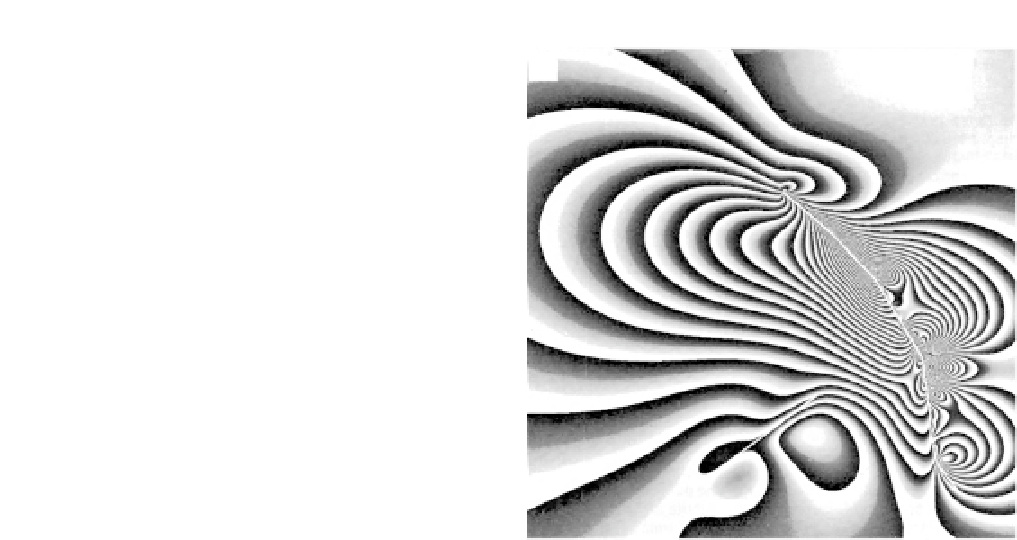
Fig. 5.17
Radar interferogram of the Landers earthquake.
A. SAR interferogram of ground displacement associated with the Landers
M
w
= 7.3 earthquake of June 1992. Each
fringe represents 28 mm of displacement, and at least 20 fringes are visible near the fault (equal to 560 mm of
displacement). Coherence is lost as the ground rupture is approached, probably because the displacement gradient is
greater than 28 mm/pixel. Note the broad, asymmetric deformation in an east-west direction covering >75 km and the
abrupt termination of major deformation near the ends of the fault. The detailed deformation patterns seen here can
be used to constrain models of surface displacement due to the Landers rupture. B. Modeled interferogram pattern
based on eight fault segments rupturing along vertical planes in an elastic half-space. The excellent match between
the observed and modeled results indicates that a simple half-space model can quite successfully mimic the observed
deformation pattern. Modified after Massonnet
et al
. (1993).
previously known to be connected. Eight
separate ruptures of varying sizes have been
hypothesized along different segments of the
fault. The complex suite of interferometry
fringes, particularly along the eastern side of the
fault, can be roughly interpreted to depict the
effects and sphere of influence of these individ-
ual ruptures. The analysis also shows that the
earthquake appears to have triggered slip on
other faults as much as 100 km from the primary
rupture. It is possible not only to look at the
direct effects of an earthquake shortly after the
event, but also to examine continuing ground
deformation in the subsequent months and
years. Continuing interferometric studies of the
Landers region following the June 1992 earth-
quake have recorded deformation of up to 10 cm
due to a magnitude 5 aftershock on a nearby
fault and have shown that less than 28 mm of
post-seismic and interseismic slip has occurred
in other areas (Massonnet
et al
., 1994).
Recent InSAR studies have also delineated
surprising seasonal changes in uplift and
subsidence that are largely unrelated to
tectonics. For example, wet winters and
subsequent runoff fill aquifers in alluvial fans
and inflate their surfaces. As the aquifers are
drawn down, especially by groundwater
pumping in summer months, the ground surface
subsides. In some parts of the Los Angeles
basin, for example, the height of the ground
surface varies by more than 10 cm over the
course of a year. In addition, the flexure induced
by the groundwater loading and unloading
causes nearby GPS sites to move horizontally as
much as 15 mm. Such rates are much greater
than any tectonic signal and have to be
accounted for in order to discern the underlying


