Geology Reference
In-Depth Information
20
0
10
afterslip
0
coseismic
slip
-10
10
-20
North
transitional
crust
GPS
Data
-30
20
East
20
10
Afterslip
Model
0
Moho
30
-10
30
20
10
0
10
A
B
2004 2005
Time (years)
Distance from coast (km)
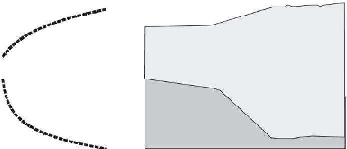
Fig. 5.16
Geodetic record of afterslip.
A. Continuous GPS data for two years following the 2003
M
= 6.9 Boumerdes earthquake in Algeria shows a
time-dependent logarithmic decay in displacement. Notice that having continuous GPS data allows smoothing
through the noise of day-to-day measurements that sometimes show large deviations (>15 mm) from their average
position. B. Geological reconstruction of the geometry of afterslip. Although modeling of the GPS data indicates
slip occurred up-dip of the coseismic rupture, no surface offset is observed. Instead, the afterslip deformation may
be absorbed within the 5-km-thick sedimentary sequence overlying the rupture surface in the basement.
Modified after Mahsas
et al
. (2008).
One persistent conundrum in tectonics
emerged from geodetic observations showing
that the convergence rates at some trenches
were greater than could be accounted for by
coseismic slip at these sites. Answers to this
problem began to emerge in the late 1960s,
when geodetic measurements after earthquakes
(Smith and Wyss, 1968) revealed the occurrence
of afterslip: accelerated, but slow, fault slip
following an earthquake. Some subsequent
studies have demonstrated that the amount of
energy released by afterslip approaches the
energy released coseismically (Heki
et al
., 1997;
Chlieh
et al
., 2007). Whereas afterslip is now a
commonly recognized phenomenon, where
afterslip occurs in the crust and what controls its
character are still debated. Does it occur along
the very same part of the fault that ruptured
coseismically, below the ruptured region, above
it, or in the rocks enclosing the fault? Where
afterslip occurs within the crust has important
implications for paleoseismological studies.
As described in the next chapter, paleoseis-
mological reconstructions commonly rely on
displaced stratigraphic, structural, or geomor-
phic features to calculate the amount of slip that
occurred in past earthquakes. But, what if a
significant fraction of the observed displace-
ment occurred as afterslip? In such a case,
coseismic slip and, hence, the magnitude of past
earthquakes could be overestimated.
Geodetic studies, especially dense GPS arrays
around recently ruptured faults, can provide
insights on both the magnitude and location of
afterslip. In general, the deeper in the crust that
the afterslip occurs, the broader the anomaly at
the surface. GPS studies following the 1999
M
=
7.5 Izmit earthquake on the North Anatolian
Fault in Turkey concluded that afterslip in the
subsequent three months amounted to
∼
10% of
the coseismic slip, that almost all of it occurred
below the coseismic rupture, and that the
afterslip was indicative of the transition to
stable fault creep at the base of the seismogenic
zone (Reilinger
et al
., 2000). In contrast, six
continuous GPS stations installed following the
2003
M
=
6.9 Boumerdes earthquake in Algeria
revealed a logarithmic decay in the rate of