Geology Reference
In-Depth Information
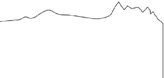
A
Primar
y Structures
Kathmandu
valley
G
reater Himalaya
Tibetan Platea
u
Siwalik
Plains
Lesser Hima
l
aya
Asian Plate
Main Boundary Thrust
0
Main Frontal Thrust
Main Himalayan Thrust
*
*
earth-
quakes
30
Indian Plate
s
error envelope
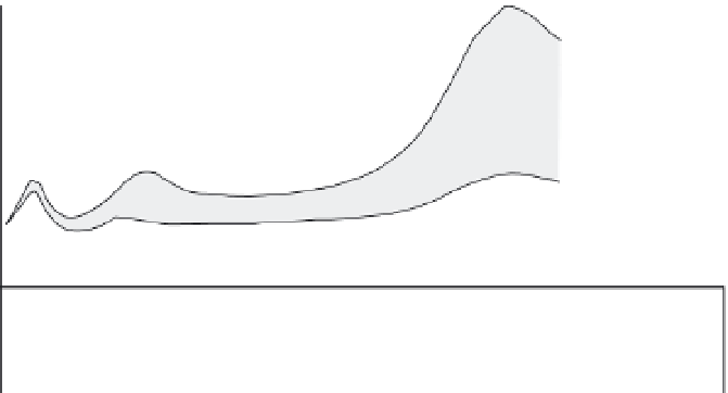
1-
B
Leveling-Line Data
12
modeled
deformation
based on slip
model
modeled slip
rate segment
rock uplift in
Greater Himalaya
8
5 mm/yr
modeled deformation
4
leveling line
data
0
C
0
1.5 mm/yr
5
mm/yr
Horizontal
velocity
1 mm/yr
5 mm/yr
20°
Slip Model
16 mm/yr
18 mm/yr
40
160
0
40
80
Distance N10°E (km)
120
Fig. 5.7
Leveling-line data in an active orogen.
Comparison of (A) large-scale structure and topography with (B) observed and (C) modeled rock uplift rates. Relative
rock uplift rates are calculated along a 250-km-long spirit-leveling line (B) oriented approximately perpendicular to
the Himalayan Range in central Nepal. From the profile's origin at its southern end, errors become cumulatively larger
to the north. The southernmost peak of uplift (
∼
2 mm/yr) is interpreted as a response to a growing anticline above the
Main Frontal Thrust in the foreland. No distinct topographic signature is associated with this deformation, probably
due to ready erosion of the uplifting, but weak strata. Slow rock uplift occurs above the Main Boundary Thrust,
whereas relative subsidence prevails in the intermontane Kathmandu region of the Lesser Himalaya. Relative uplift
within the Greater Himalaya occurs at the highest rates (
∼
6 mm/yr) and is associated with high topography, suggesting
some permanent strain. C. Finite-element modeling of deformation of an elastic crust assigns variable slip to different
fault segments. Note the striking rate change from 18 mm/yr in the north to 5 mm/yr to the south of the steeper
crustal ramp lying beneath the Greater Himalaya (Bilham
et al
., 1997). This abrupt gradient suggests that strain
above and south of the crustal ramp could generate the observed pattern of uplift. In particular, the strong
southward-sloping gradient in uplift within the Lesser Himalaya is consistent with a large component of elastic
interseismic strain that should be released in future large earthquakes. Modified after Jackson and Bilham (1994a).
of the data by dividing the survey into segments.
Within these segments, the uncertainty is smaller
with respect to the signal, and differential uplift
or subsidence can be more reliably determined.
Despite many researchers' preference for
using new technologies, such as GPS, to collect
geodetic data, leveling surveys can still provide
some of the highest-quality, longest-duration
measurements of vertical deformation, as well
as compelling insights on patterns of crustal
deformation. For example, comparisons of
spatial variations in vertical uplift rates with