Geology Reference
In-Depth Information
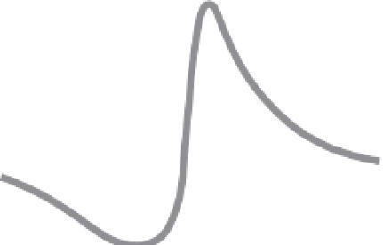
Deformation from
a
Subduction-Zone Earthquake
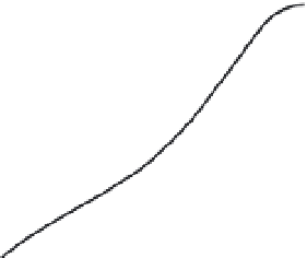
0.6
1952 Kern County
earthquake
data
model
Anchorage
0.4
0.2
0.0
Coseismic
Deformation
During
Thrust Faulting
-0.2
A
-0.4
N
North
South
0
200
km
Middle Miocene
Lower
Miocene
-1
vertical
displacement
Pliocene
-2
Geologic
Structure
-3
Fig. 4.29
Displacement due to the 1964 Alaska
(
M
w
= 9.2) earthquake in the Aleutian subduction
zone.
Over 2.4 × 10
5
km
2
were deformed by this megathrust
earthquake. Strong uplift (up to 10 m) occurred in an
elongate zone in the proximal hanging wall, and lesser
subsidence (up to 2.5 m) occurred in more distal parts
of the hanging wall. Most of the deformation is
determined from displaced shorelines. Footwall
deformation (outboard of the trench) due to the
earthquake remains unknown. Modified after Plafker
(1972) and Lajoie (1986).
Lower
Miocene
-4
correlative unit
across fault
-5
vertical = 9 x horizontal
B
-6
-40
-20
0
20
40
Distance (km)
Fig. 4.28
Short- and long-term deformation due to
thrust faulting.
A. Coseismic thrust displacement during the 1952 Kern
County, California (
M
= 7.3) earthquake. Note the
asymmetry of hanging-wall uplift and footwall subsidence
and the large wavelength of flexure. B. Geological
cross-section of the footwall basin and hanging-wall block
of the White Wolf Fault that ruptured during the Kern
County earthquake. Miocene marker beds are offset about
5 km. Note that the Miocene units do not thicken
appreciably as they approach the fault. This uniformity
suggests that the fault did not become active until
Pliocene time. Modified after Stein
et al.
(1988).
greater than 9 have ruptured subduction zones in
the Pacific and Indian Oceans: the 1960 Great
Chilean (
M
w
=
9.5) earthquake; the 1964 Alaskan
(
M
w
=
9.2) earthquake; the 2004 Sumatra-
Andaman (
M
w
=
9.1) earthquake, and the 2011
Tohoku-Oki (
M
w
=
9.0) earthquake (Satake and
Atwater, 2007). Each of these large earthquakes
had rupture lengths of 800-1600 km, coseismic
displacements of 15-50 m, and deformed huge
areas. For example, the 1960 Alaskan earthquake
along the Aleutian subduction zone (Wyss and
Brune, 1967) deformed a region over 350 km
wide and about 800 km long (Fig. 4.29). The
hanging wall experienced spectacular uplift
(maximum of 8-10 m) across a 200-km-wide
zone on the north side of the Aleutian Trench,
whereas, still farther north, the hanging wall
subsided up to 2.5 m within a 150-km-wide zone
(Fig. 4.29). It may at first seem surprising that
considerably less than in the Borah Peak rup-
ture (
∼
150 cm; Fig. 4.25), the width of the
deformed zone was twice as wide, apparently
due in large part to the higher crustal rigidity in
the vicinity of the Kern County earthquake.
Convergent plate margins have produced most
of the earthquakes of very large magnitude in the
past 100 years. The interface between overrid-
ing and underthrusting plates commonly repre-
sents an irregular, earthquake-prone, regionally
extensive surface. Since 1960, four megathrust
earthquakes with moment magnitudes (
M
w
)