Geology Reference
In-Depth Information
Regional Tilting due to Normal Faulting
maximum
subsidence
landslide
dam
4
N
5
6
Quake
5 km
Lake
6
5
5
Madison
Range
4
5
Fault
3
Hebgen
Lake
2
1
Hebgen
Lake
South
Fork
0.5
N
10 km
antithetic
faults
subsidence
(meters)
pre-faulting alluvial surface
with contours (12-m interval)
2
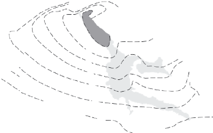
Fig. 4.26
Ground displacement resulting from the 1959 Hebgen Lake (
M
= 7.3) earthquake in west Yellowstone.
Maximum offsets of more than 6 m occurred adjacent to the Hebgen Lake Fault. Note the complex three-dimensional
geometry of displacement and the small antithetic faults in the south(east). Minor offsets are associated with the
Madison Range Fault, whereas additional large offsets occurred along the Red Canyon Fault. The Madison River was
dammed by landslides triggered by this earthquake. Given the sensitivity of rivers to small changes in gradient,
fault-induced tilting should cause rivers to migrate toward the zone of maximum subsidence. Inset shows gradient
of pre-earthquake, northwest-oriented depositional surface. Modified after Alexander
et al.
(1994).
isostatic uplift due to erosion of the footwall
block often increase the total bedrock uplift
within the footwall. Despite this footwall uplift,
the load of sediments that accumulates in and
depresses the hanging-wall basin guarantees
that considerable asymmetry in net displace-
ment usually persists. At Borah Peak, Thousand
Springs Valley represents a half-graben that has
accumulated the sediments eroded from the
rising footwall (Fig. 4.25A and D). Crustal flexure
due to the earthquake affected an area at least
35 km wide (Fig. 4.25C).
In three dimensions, the pattern of uplift
and subsidence resulting from multiple surface
ruptures during a single earthquake can be
complex. As a result of the 1959 Hebgen Lake
(
M
=
7.3) earthquake in western Yellow-
stone National Park, maximum subsidence
(
∼
7 m) occurred along the middle segment of
the Hebgen Lake Fault and decreased system-
atically toward either tip and away from the
fault (Fig. 4.26). But, the nearby Red Canyon
Fault has a highly curved trace, so that in
places the contours of subsidence strike at
high angles toward one margin of the fault and
imply that this margin acted as a transverse
structure or hinge along the side of a scoop-
shaped zone of subsidence that strikes at right
angles to the elongate zone of subsidence
along the Hebgen Lake Fault (Fig. 4.26). In
contrast to the observed displacement on the
Hebgen Lake Fault and to fault models of
decreasing displacement toward the fault tips,
displacement on the Red Canyon Fault is highly
asymmetric and suggests that the western
termination of that fault acts as a “free bound-
ary” where it abuts the Hebgen Lake Fault
(Fig. 4.26).