Geology Reference
In-Depth Information
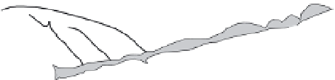
A
Scarp
Offset drainage channel
Beheaded
Stream
Of
set d
rainage channel
Shutter ridge
Spring
Sag Pond
Linear valley
Bench
Scarp
Linear valley or trough
Older fault
trace
Geomorphology of
Strike-Slip Fault Zones
B
Apparent fault tip
Principal dis-
placement zone
PDZ
PDZ
C
BC
Beheaded channel
Ofset channel
Shutter ridge
OC
SR
Principal dis-
placement zone
PDZ
BC
BC
PDZ
OC
OC
SR
OC
OC
BC
Fig. 4.21
Geomorphology of strike-slip fault zones.
A. A linear trough along-fault, sag ponds, shutter ridges, offset ridges and drainages, springs, scarps, and beheaded
streams are typical geomorphic features indicative of strike-slip faulting. The older, abandoned fault trace displays
analogous, but more erosionally degraded features. Modified after Wesson
et al.
(1975). B. Lidar-based shaded relief
map of the sinistral Garlock Fault zone in southern California: 35
°
23
′
58
″
N, 117
°
48
′
1
″
W. Note complex faulting by
normal faults oriented obliquely to the principal displacement zone (PDZ). C. Lidar image of offset channels (OC),
beheaded channels (BC), and shutter ridges (SR) along the Garlock Fault: 35
°
26
′
22
″
N, 117
°
41
′
42
″
W. Images courtesy
of the U.S. Geological Survey, Google Earth© and Earthscope Geon Open Topography Portal.