Global Positioning System Reference
In-Depth Information
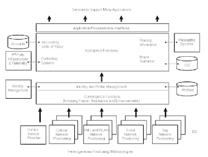
Figure 3.2
Methodology for the provision of general Whereness services.
At the bottom of the diagram are a series of positioning systems, all, some, or
none of which may be owned by the operator but all of which have an agreement
to pass positioning information. Convergence functions for each of the systems
convert information into a common format. Above convergence comes the trust
layer managing identity and service profiles for all customers. External systems
may be used to manage identity operated by other parties. A common interface is
then presented to a set of intelligence functions that perform the value-added
functions and that rely on many external systems and data sources, in particular a
GIS. Applications are then supported via a common API that may become
standardized across the emerging Whereness industry.
This approach is flexible and to an extent future proof. Extra positioning
systems can be added and new convergence handlers written without changing the
internal common approach. The API can be extended or even better, written so
that the future functions are already present but not presented until operational.
However, it should be remembered that this diagram makes no statement
about the colocation of functions, as it is a logical diagram, and it is very likely
that a very distributed approach will be taken in the future with many of the
functions actually running on user hosts and not central servers. Centralized
functions are there for support, convergence, and occasional synchronization
rather than for continuous sessions.