Global Positioning System Reference
In-Depth Information
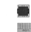
Figure 7.5
A typical three-axis accelerometer chip and solid-state gyro module.
7.5.3
Accelerometers and Gyroscopes
Accelerometers and gyroscopes take many forms, some of which are used only in
aerospace and military applications. Accelerometers function by measuring the
displacement of a mass due to gravity or inertia but it is the recent availability of
highly miniature devices based on MEMS technology that is having the most day-
to-day impact. Microelectromechanical systems (or MEMS) are devices that are
nonelectronic components constructed using silicon chip fabrication processes.
For example, a simple flexible cantilever will act as a one-dimensional
accelerometer. If it is mounted on top of a silicon chip, the flexing of the beam can
affect the capacitance of an integrated capacitor, which in turn can alter the
frequency of an integrated electronic oscillator, which can then have its frequency
counted in a processor subsystem and so on until the acceleration information is in
the desired format for navigation or some other application. If three similar
cantilevers are made and mounted in three planes, three-axis acceleration can be
measured and a full three-dimensional motion model can be used.
When following a route a gyroscope is useful to provide headings and is not
the subject of external influence (as would be the case were a simple magnetic
compass used). Both accelerometers and gyroscopes do not provide absolute
references so there is a need to link their relative reference frames to that used in
any associated map and the real world. For this reason both gyros and
accelerometers are often combined with other positioning devices. For example, a
gyro can be calibrated versus a magnetic compass and will then be useful to show
when the compass is indicating anomalies. Likewise, accelerometers suffer from
drifting errors especially during slow motion, so they can be calibrated against a
radio-based system that may be intermittent.
It is usual, therefore, to combine GPS systems with inertial systems. The
former can provide an absolute position but with outages due, for example, to
poor sky visibility, and the latter can fill in the coverage gaps.