Travel Reference
In-Depth Information
so far that he had already worn out several pairs of shoes on the way from it. The
Devil lost heart and emptied his wheelbarrow-load of stone which became, of course,
Cam Long Down. (Similar folk legends occur all over the country.) Strip lynchets (ter-
races or ridges) may be seen on the south-facing slopes, while the summit plateau is
rumpled with strange undulations that indicate the possible existence of some form of
ancient settlement.
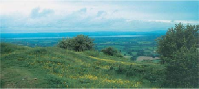
The rumpled crest of Cam Long Down suggests it may once have been the site of an
ancient settlement
A wonderful panorama is to be seen from here: the windings of the
Severn to the west, now a wide river of substance with the Forest of
Dean as backing, the curving Cotswold escarpment, the clustered streets
of Dursley below to the south-west, and Downham Hill to the south. There
are more tiny villages to the north, green meadows set between hedgerow
envelopes, and a wonderful sense of space.
Cross the ridge to its western end, then begin the descent to Dursley.
The path soon forks, and you take the left branch which leads to a multi-
junction of paths on the saddle connecting Cam Long Down with Cam Peak
(Peaked Down). Go half-left ahead on a minor path to skirt the lower,
southern slope of
Cam Peak
, and very soon you'll come alongside a fence.
About 50 metres later cross a stile on the left, then walk down the lefthand
edge of a sloping meadow, at the bottom of which you come to a lane by
farm buildings.
CAM PEAK
Cam Peak (Peaked Down on the OS maps) is a secondary hill of 604ft (184m) standing
just to the south-west of Cam Long Down to which it is connected. The former route of
the Cotswold Way crossed its summit, and gives similar magnificent views to those of