Travel Reference
In-Depth Information
Smyllie Reserve (in the care of the organisation 'Butterfly Conservation').
Maintain direction on a path which eventually curves left, then forks. Take
the right branch.
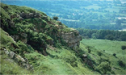
Making a traverse of Cleeve Common, Castle Rock can be seen on the scarp edge
Coming out of a section enclosed by bushes, cross an open area and
leave the butterfly reserve over a stile. The way now continues between
gorse bushes. Coming to a four-way crossing, turn right and slope downhill
a little, still among gorse, then reach a major crossing path. Bear left uphill
for a few paces to reach a pole supporting overhead cables, where a way-
mark directs you to the right onto a sunken track sloping gently downhill,
with a disused quarry on your left.
The track brings you to a gate at the top of a narrow, surfaced lane. Go
through the gate and branch left on a footpath aiming alongside woods
with a large meadowland stretching away to your right. At this point fine
views show across the valley to the continuing Cotswold escarpment.
At the end of the woods bear left along a narrow country lane through
an avenue of splendid beech trees.
At a minor crossroads turn right. This lane also has a row of ancient pol-
larded beech trees alongside it. When it curves sharply leftwards leave the
lane and continue straight ahead through a kissing gate, then along an en-
closed track with a drystone wall on your right.
Over the wall there are views
to enjoy of the distant Black Mountains.
When the wall ends the track continues
ahead, leading to a very narrow lane (grid ref: 991211).
Across the lane go through a kissing gate and walk ahead along the
right-hand edge of a field. Halfway down, a waymark directs you half-left
across the field to another kissing gate about 30 metres left of barns at