Travel Reference
In-Depth Information
oolitic limestone that was pushed up to form the very backbone of the
land, and which provided the stone that has since been used for the con-
struction of countless lovely cottages, manor houses and churches, not to
mention the long miles of drystone walling seen almost everywhere.
The Cotswold mass has an eastward tilt, with the sharp face of the es-
carpment to west and north, and the limestone resting on several thick-
nesses of soft Lias clays. Thanks to that tilt, natural weathering processes
are aided in their slow but steady destruction of the whole area: streams
are constantly weakening the scarp slope, the clays slip and overlying rock
crumbles without its former support. Thus the scarp has become a corrug-
ation of bays and projecting prows, similar to a coastline, but without the
tides of an ocean lapping at its base. Yet even without the wash of tides
the scarp is being worn away and pushed further east and south. 'Outliers'
such as Cam Long Down near Dursley, Bredon Hill near Evesham, and
Dundry Hill to the south of Bristol, provide evidence of the former position
of the Cotswold scarp and suggest that the wolds once spread throughout
the Severn Vale.
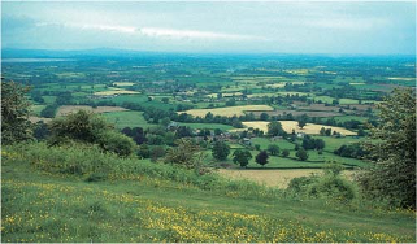
Cam Long Down, one of the outliers detached fromthe main Cotswold escarpment, is a
very fine viewpoint Section 8 southbound, Section 6 northbound)
At the end of the last ice age, some 10,000 years ago, the bare bones
of the Cotswolds were given a flesh of vegetation. At first, no doubt, the
wolds would have been colonised by deciduous woodlands, but in Neolithic
times clearings were made and primitive forms of agriculture attempted
on the virgin land. With successive generations the open spaces grew un-
til, by the Middle Ages, the Cotswolds were one vast sheepwalk. Then the
process of agricultural evolution exchanged pasture for arable land and,