Geography Reference
In-Depth Information
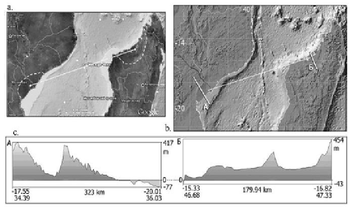
Figure 30. Contours of the Madagascar-1 crater ina Google Earth map [62] (a), a GIS-
EISC digital elevation model(b), and in cross sections along profiles A and B (b)
showing the entire crater ring (in GIS-EISC) (c).
Following the coastline contours (Figures 30: a-b) one can trace a
probable location of the Africa-Madagascar junction (separated no earlier than
150 Ma). The fault line (underwater line in Figure 30b) breaking the RS in half
is parallel to the major axis of the structure and, possibly, to the ballistic
trajectory of a falling cosmic body (the direction of impact). The Madagascar
half of the crater is shifted, likely due to velocity difference of the Madagascar
terrane relative to the African plate. The seafloor motion direction is
confirmed by the map of linear magnetic anomalies for the adjacent spreading
zone [62, 71].
Thus, the new approach, with the updated morphological diagnostic
criteria revealed by GIS technology and remote sensing, allows identifying
impact craters even if they have been affected by active geological processes.
The potentialities of the EISC and EEDB GIS systems have been
combined into a single version of GIS ENDDB, using gravimetric data
uploaded into the GIS Database for both seismological and impact cratering
applications.