Geography Reference
In-Depth Information
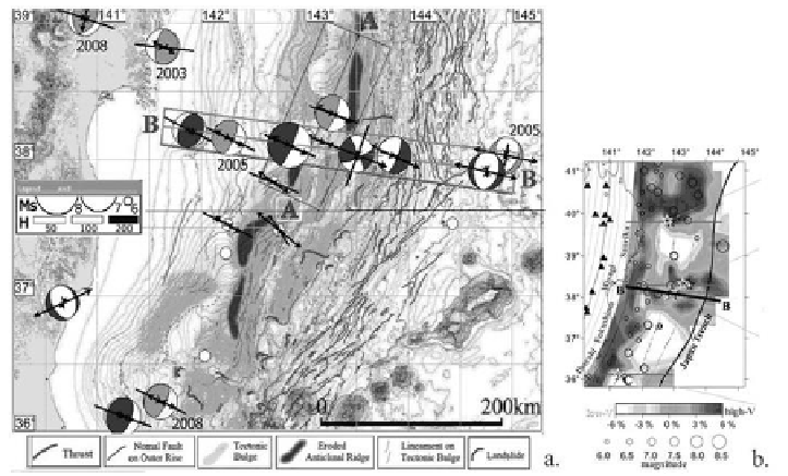
Figure 17. The rigid linear structure (BB): a) tectonic geomorphological map [48]
(thin- and heavy-line circles show events before and after the Tohoku event,
respectively); b)
P
-wave tomography image [50].
Incorporating this tectonic map as a
background map
into the GIS EEDB
system and visualizing great earthquakes (in the mode of
drawing focal
mechanisms
) (Figure 17), we can see that the events of this chain are localized
in a gap between elongate tectonic uplifts and belong to seismotectonic
segments of different slip geometries (reverse, strike-slip, and normal):
•
first three earthquakes (left) in the chain, including the shallower
foreshock of the Tohoku event located just to the north (Miyagi-oki
event of 9.03.11) and the remote response in the southern part of the
region, have compressive reverse-slip mechanisms;
•
the event in the middle has a strike-slip mechanism;
•
three events on the right have extensional normal-slip mechanisms.
Frequent changes in geodynamic regimes is characteristic of the plate
boundary separating the North American, Eurasian, Pacific and Okhotsk plates
[49] and corresponds to a change in directions of major tectonic strain in this
region.
The
profile
AA (Figure 17a) striking along the main tectonic structures
shows that the area between the Tohoku event and its foreshock was still
weakly active after the event, though the center of the earthquake swarm had