Geography Reference
In-Depth Information
GIS systems can help to automate and therefore optimize the processes
mentioned above.
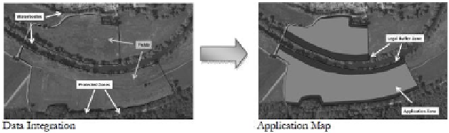
One option is to automate the spraying process and the protection of
adjacent natural and aquatic ecosystems by using GIS-created application
maps, that include legal buffer zones, where spraying is prohibited. These
maps can then be aplied to sprayer terminals.
ZEPP and ISIP have, in cooperation with different project partners
1
,
developed an internet-based DSS that creates such application maps (Scheiber
et al. 2012, Scheiber and Kleinhenz 2013a -d). Figure 1 describes the under -
lying concept:
The DSS consists of six steps, in which data from the farmer as well as
public information and geodata are integrated (Figure 2). Each step will be
described in detail in the following:
Step 1: GNSS Survey of Field Geometries, Water Bodies and
Terrestric Structures
The process starts with the mapping of field geometries and sensitive
landscape areas adjacent to the field. Geodata about water bodies and terrestric
structures like hedges or skirts of the forest are necessary to be able to
calculate the required buffer zones.
A technical procedure how to conduct such surveys has been developed. A
GNSS-RTK based approach is promoted, which reaches an accuracy of up to
just a few centimeters. The procedure allows the farmer to map the applicable
landscape elements during a tractor ride using an off-set method. It has been
developed in cooperation with German supervising authorities to promote that
data recorded this way are officially accepted.
Figure 1. Concept of creating application maps.
1
http://www.igreen-projekt.de.