Environmental Engineering Reference
In-Depth Information
cell
i
cell
i
i
u
i
(
t
)
u
i
(
t
)
outlet
t
t
(a)
(b)
(c)
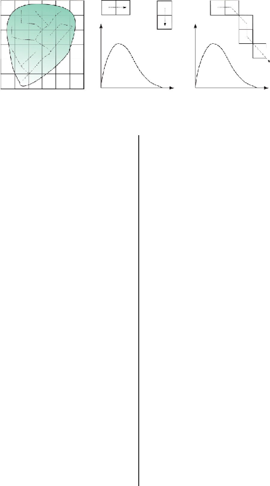
FIGURE 18.3
(a) Catchment and stream network, (b) unit impulse response function for a single cell, (c) path impulse
response function as a convolution of unit impulse function of cells along a flow path (Mohammed, 2009).
18.5
Impact of different
approaches for estimating
impervious surface cover on
runoff calculation and
prediction of peak
discharges
input runoff volume. This is equivalent to decomposing the input
into infinite impulses and summing all the responses to get a
single response. Consequently, the outflow hydrograph to an
arbitrary input can be determined as
t
−
τ
Q
i
(
t
)
=
V
i
(
τ
)
U
i
(
t
−
τ
)
(18.6)
τ
=
0
where
Q
i
(
t
)[L
3
T
−
1
] is the outflow at the end of a flow path
produced by an arbitrary input in cell
i
,
U
i
(
t
−
τ
)istheflow
path response function,
τ
[T] is the time delay, and
V
i
(
τ
)[L
3
]
is the input runoff volume at cell
i
and time
τ
.Flowresponse
of the catchment is the sum of the response of the contributing
cells as
The remainder of this chapter reports on a case study in
which high-resolution and medium-resolution land-cover maps
derived from remotely sensed data were used to estimate the
distribution of impervious surfaces and other land-cover types
within the urban classes of an existing land-use map for the
Brussels Capital Region. The ''remote sensing enhanced'' ver-
sions of the land-use map were used as input for a rainfall-runoff
simulation on the upper catchment of the Woluwe River, located
in the southeastern part of the Brussels region. The impact of
different methods for characterizing urban land-cover on esti-
mated runoff patterns and on peak discharges at the outlet of the
catchment has been examined. One of the objectives of the study
was to examine how sub-pixel estimation of impervious surface
cover based on medium-resolution data (Landsat ETM
N
w
Q
(
t
)
=
Q
i
(
t
)
(18.7)
i
−
0
where
Q
(
t
) is the total flow at the catchment outlet and
N
w
is the
number of cells in the catchment.
18.4.3
Water balance
In WetSpa, water balance computation is carried out in four
control volumes: interception storage, depression storage, root
zone and saturated subsurface. If we consider the root zone as an
example, its main input is infiltration (
F
) and its main outputs are
evapotranspiration (
ET
), lateral interflow (
RI
)andpercolation
to the groundwater storage (
RG
). Then, the water balance in the
root zone with thickness
D
for a single cell
i
at time
t
can be
written as
+
,30m
resolution) compares to detailed mapping of impervious surfaces
using high-resolution satellite data (IKONOS, 4 m resolution) in
terms of runoff and peak discharge prediction, using the WetSpa
distributed hydrological model.
18.5.1
Study area and data
F
i
(
t
)
−
ET
i
(
t
)
−
Rl
i
(
t
)
−
RG
i
(
t
)
=
D
i
[
θ
i
(
t
)
−
θ
i
(
t
−
1)]
(18.8)
where
θ
i
(
t
)and
θ
i
(
t
-1) [L
3
L
−
3
] are the soil moisture content
of cell
i
at time
t
and
t
-1,
D
i
[L] is the root depth. The same
principle is extended to the other control volumes based on the
inputs and outputs in the control volumes. To keep track of water
change in the entire catchment, an additional water balance is
computed for the entire catchment using rainfall as the driving
input and runoff and evapotranspiration as an output to yield a
change in soil moisture and groundwater storage.
The WetSpa model, documentation, and examples are avail-
able from http://www.vub.ac.be/WetSpa/.
TheWoluweRiverisatributaryoftheZenneRiver,which
runs through the center of Brussels, and is part of the Scheldt
basin. The study area consists of the upper part of the Woluwe
catchment and has an area of about 31 km
2
. The upstream part
of the study area is located in the protected zone of the Sonian
forest, southeast of the city center of Brussels. In the downstream
part, the Woluwe River flows partially through several vaulted
stretches, parks and ponds. The elevation of the catchment varies
between 49 and 129 m, with an average of 94 m above sea
level. The elevation decreases gradually from south to north,


Search WWH ::

Custom Search