Environmental Engineering Reference
In-Depth Information
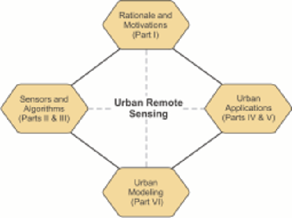
FIGURE 1.1
A graphic overview of the topic structure.
developing urban socioeconomic and environmental indica-
tors; and
●
Examines the developments of remote sensing and dynamic
modeling techniques for simulating and predicting urban
growth and landscape changes.
The sections to be followed will discuss the benefits and
possible challenges of using remote sensing for urban studies,
provide an overview of the major topics discussed in the topic,
and highlight several areas that need further research.
In addition to scientific research, the topic has incorporated
a management component that can be particularly found in
the chapters discussing urban socioeconomic and environmental
analyses and predictive modeling or urbanization. Cutting-edge
remote sensing research helps improve our understanding of
the status, trends and threats in the urban environment; such
knowledge is critical for formulating effective strategies towards
sustainable urban planning and management.
Unlike most edited topics with a contributing author pool
from a single event, this topic is written by a carefully selected
group of interdisciplinary scholars:
1.2
Remote sensing and
urban studies
The technology of modern remote sensing began with the inven-
tion of the camera more than 150 years ago, and by now a
wide variety of remote sensing systems has been developed to
detect and measure energy patterns from different portions of the
electromagnetic spectrum. Remote sensing can help improve our
understanding of urban areas in several ways, although the realis-
tic potential for making these improvements is often challenged
by the complexity in the urban environment.
Remote sensing provides several major benefits for urban
studies. First, perhaps the largest benefit of remote sensing is
its capability of acquiring photos or images that cover a large
area, providing a synoptic view that allows identifying objects,
patterns, and human-land interactions. This unique perspective
is highly relevant to the interdisciplinary approach we advocate
to study the urban environment in this volume since many
urban processes are operating over a rather large area; failure
in observing the entire mosaic of an urban phenomenon may
hinder our ability to understand the potential processes behind
the observed patterns.
Second, remote sensing provides additional measures for
urban studies. Urban researchers frequently use data collected
from field surveys and measurements. This way of data collec-
tion is considered to be accurate but can introduce potential
errors due to the bias in sampling design (Jensen, 2007). Field
measurements can become prohibitively expensive over a large
area. Remote sensing can collect data in an unbiased and cost-
effectiveness fashion. Moreover, remote sensors can measure
energy at wavelengths which are beyond the range of human
vision; remote sensor data collected from the ultraviolet, infrared,
microwave portions of the electromagnetic spectrum can help
●
Researchers who presented a scholarly paper in an urban
remote sensing session the author has organized at the annual
meetings of the Association of American Geographers (AAG)
since 2000;
●
Researchers who recently presented a scholarly paper at a
Joint Urban Remote Sensing Event;
●
Some active researchers largely identified from their recent
presentations at several other remote sensing conferences
(e.g., annual meetings of American Society for Photogram-
metry and Remote Sensing or International Geoscience and
Remote Sensing Symposium); and
A small number of other world-class scholars in remote
sensing, geocomputation, urban studies, geography, and envi-
ronmental science.
●
A total of 59 authors from Belgium, Canada, Germany,
Israel, Italy, Poland, Sweden, the United Kingdom, and the
United States contribute to this topic. Although this topic is
authored by US and European scholars with case studies predom-
inately drawn from North America and Europe, the knowledge
gained from these two regions can be applied to other urban
areas globally.


Search WWH ::

Custom Search