Environmental Engineering Reference
In-Depth Information
P
GwPark
Parks
Clip
Project
GwPark sp
Erase
P
Erased
Park
GwAirport
sp
Airports
Clip (2)
GwAirport
Project (2)
P
P
Erase (2)
Erased
Airport
Output
Coordinate
Gwinnett
P
Erased
Landmark
Landmark
Areas
Gw
Landmark
Gw
Landmark
Erase (3)
Clip (3)
Project (3)
P
HwyBuffer
Distance
P
Project (4)
Highways
Clip (4)
GwHwy
GwHwy sp
HwyBuffer
Erase (4)
Buffer
P
Erased
Hwy
InterstateBuf
fer Distance
P
Interstate
Buffer
GwInterstate
sp
Buffer (2)
Erase (5)
Project (5)
Clip (5)
GwInterstate
Interstates
P
Erased
Interstate
Rail Buffer
Distance
P
Clip (6)
GwRail
Erase (6)
Project (6)
GwRail sp
Buffer (3)
Rail Buffer
Railroad
P
Shadow indicate
model has been run
GwClipedMask
Input Data
Tools
Output Data
Input Value
P
Gw_Blockgroup
00
Add Filed
VALUE1_area
Add Filed
pop00_v1 area
Add Filed
pop00_v1_sqkm
Gw_bg00_1
Gw_bg00_2
Gw_bg00_3
P
P
GwClipedMask
Extract by
Mask
NLCD01_Gw_
Clip
Rec_NLCD01
Clip
Tabulat_gw_
bg00
Reclassify
Tabulate Area
Add Join
Gw_bg00_4
P
P
Calculate
V1-area
NLCD2001
Gwinnett
Reclassification
Gw_bg00_5
Gw_bg00_6
Calculate
pop_V1 area
Gw_bg00_7
Calculate
pop_V1
_
sqkm
Remove Join
P
Bg00PopSqkm
Residential
Bg00PopSqk
m
Polygon to
Raster
Gw_bg00_8
Gw_bg00_8
Times
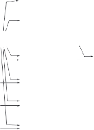
FIGURE 14.7
GIS processing flows for dasymetric mapping: (a) creation of spatial mask; (b) binary dasymetric method as
implemented.
with the provision of LULC data at low-to-no cost, make dasy-
metric mapping a very viable approach for areal interpolation
tasks.
Wright acknowledges that his dasymetric method could be
used for either population ''or of other phenomena, within the
limits of townships or other territorial units for whose subdivi-
sions no statistical data are available'', and ''
...
it might well be
applied in mapping various phenomena for which statistics are
available by counties but not by minor civil divisions'' (Wright,
1936, p. 110). Eicher and Brewer (2001) demonstrate this utility
by implementing three different methods of dasymetric map-
ping for population and data on housing values for Western
Pennsylvania.
Clearly, Wright's method, along with any of the other
dasymetric methods we described, could be used to map the
distribution of virtually any sociodemographic data. This might
include not only census-derived data, such as housing, economic,
and demographic variables, but also public health surveillance
data. The limitations in using this approach may result more
from the origin of the data themselves as opposed to limitations
in dasymetric methodology. Specifically, many public health data
are collected by surveys and the resulting sample sizes may
impose limitations due to concerns over small numbers and vari-
ance instability. In addition, public health agencies that collect
data on rare or sensitive conditions may be required to suppress
data at more granular levels due to rightful concerns over the
preservation of privacy. Nonetheless, with adequate source data,
researchers and data analysts can apply dasymetric methods to
more accurately map the distributions of sociodemographic and
health-related data.


Search WWH ::

Custom Search