Environmental Engineering Reference
In-Depth Information
the advent of very high resolution imagery and recent image
processing techniques); second, they suggest that using impervi-
ous surface extents or other morphological variables as proxies
for the degree of urbanized area can result in misclassification
errors; third, they note that building heights are not revealed
from imagery (although they subsequently admit that lidar may
provide a feasible method for estimating building heights); and
fourth, they express concerns over expense, data storage and
processing burdens, and difficulties in differentiating between
residential and nonresidential areas. Their fourth criticism is
based on a quote taken from Moon and Farmer (2001, p. 42),
which Moon and Farmer attributed to Mesev, Longley and Batty
(1996). With respect to this particular concern, which may have
been valid fifteen years ago, developments in computing capabil-
ities and image processing techniques have made this problem
less insurmountable. Maantay, Maroko and Herrmann (2007)
also criticize the use of street network data as ancillary data, sug-
gesting that this type of data is not accurate enough for densely
settled urban core areas.
Xie (2006) illustrates a related approach to using parcel data.
Rather than beginning with a cadastral database, Xie used high
resolution imagery (digital orthophotos and lidar) to extract
building-related pixels, which were then differentiated as resi-
dential and non-residential through the overlay of parcel data and
tax roll information. The key emphasis of Xie's approach is the
use of individual housing units as the most basic and meaningful
unit from which to construct a population surface. Xie's approach
represents a very innovative combination of population-related
data that are derived from various sources, which are collected
for different purposes, in order to produce a data layer with
enhanced informational value.
Wu, Wang and Qiu (2008) present a slightly different
approach to obtaining housing-unit-level population estimates.
They used building footprint data, in vector polygon format,
obtained from a metropolitan planning and zoning department,
along with census-derived housing measures. By dividing total
building volumes (the sum of building footprint area) by average
space per housing unit, they derived an estimate of the total
number of housing units. They multiplied that estimate by the
housing unit occupancy rate and the average household size to
obtain an estimate of the population at the block level.
(a) Georgia
Legend
N
Gwinnett County
Atlanta 10 County Regional Commission
Counties
State Boundary
W
E
S
0
50 100
Kilometers
200
(b) Gwinnett County
Hall
Forsyth
985
Fulton
Barrow
85
Walton
Dekalb
Legend
Limited Access
Highway
Major Road
Major Railroad Lines
N
Rivers
Airport Area
Water
Cities
W
E
14.3
Application example:
metropolitan Atlanta,
Georgia
S
0
2.5
5
10
Kilometers
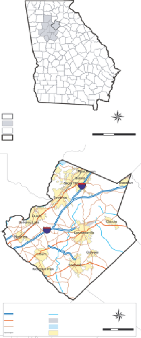
FIGURE 14.1
Location of the study area.
To demonstrate the practical utility of dasymetric mapping
for population and sociodemographic data redistribution, we
applied some basic techniques that can be performed in a
standard, commercial geographic information system (GIS) for
Gwinnett County, Georgia, USA. Gwinnett County is part of the
metropolitan Atlanta area (Fig. 14.1a), a region that has expe-
rienced substantial population growth in the past three decades
and has been the site for numerous urban geography research
studies (Yang, 2002; Yang and Lo, 2003; Lo and Yang, 2002; Lo
and Quattrochi, 2003; Lo, 2004, 2008; Holt, Lo and Hodler, 2004;
Holt and Lo, 2008). Gwinnett County (Fig. 14.1b) represents a
portion of the Atlanta metropolitan area that contains a diverse
mix of LULC classes and associated population densities. This
diversity in LULC classes and the clarity of dasymetric population
density maps were observed in previous studies of the Atlanta
area (Holt, Lo and Hodler, 2004; Lo, 2004, 2008).
14.3.1
Data
We obtained population and sociodemographic data for the year
2000 from the US 2000 decennial census (US Census Bureau,


Search WWH ::

Custom Search