Environmental Engineering Reference
In-Depth Information
a park using different decision and expert system rules. We
employed the nearest neighbor classifier to identify different
urban land-cover classes using two different combinations of
multispectral bands in the second application example.
We tested four different scale levels with the same set of
segmented parameter values for both application examples. The
default values of shape parameter (
S
sh
)0
.
1wasusedtogive
less weight on shape and give more attention on spectrally
more homogeneous pixels for image segmentation. We also
used default value of compactness parameter (
S
cm
)0
.
5 to balance
compactness and smoothness of objects equally. We employed
four different scale levels (
S
sc
) to segment objects: 10, 25, 50,
and 100. Figure 9.4 shows segmented images of a subset at
object scale level 1, scale level 2, scale level 3, and scale level 4
(scale parameters 10, 25, 50, and 100) using shape (
S
sh
)0
.
1and
compactness (
S
cm
)0
.
5.
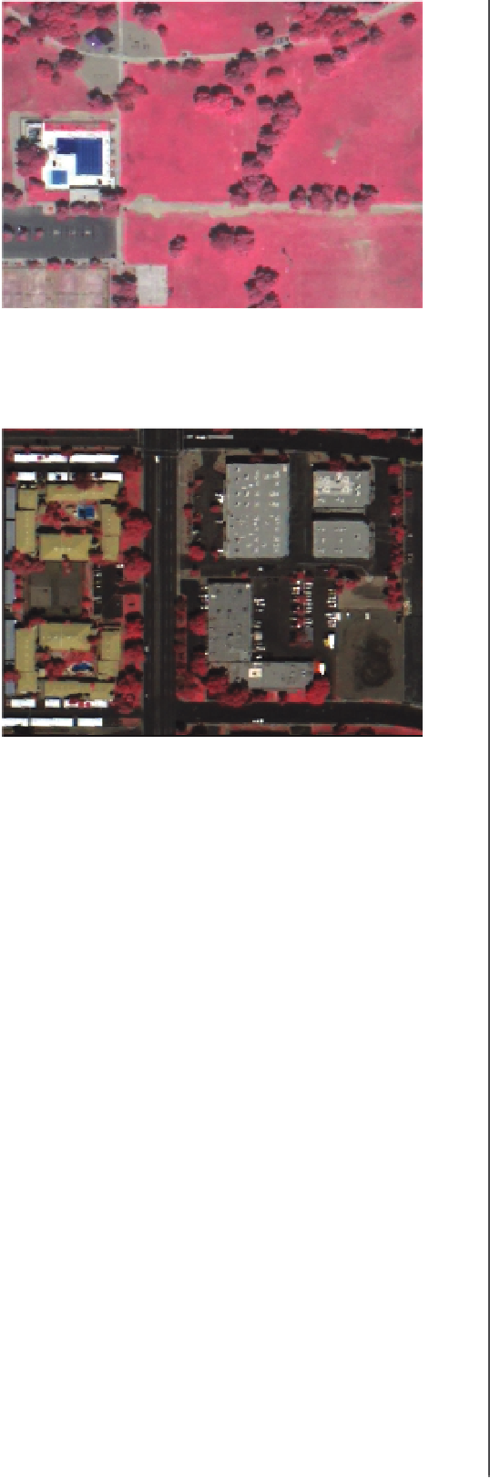
FIGURE 9.2
A false color infrared Quickbird subset cover-
ing swimming pools and surrounding land covers.
9.4.1
Rule-based detection of
swimming pools
One's expert knowledge is the most important tool for creating
a rule set for extracting a particular LULC class. In this case,
we need to use our expert knowledge to discriminate swimming
pools from other land covers. We attempted to delineate and
identify two swimming pools within a subset of the full study
area. First, we visually analyzedmany different image feature types
(i.e., wavebands and transforms) by displaying and interpreting
themon the screen. This was to see if swimming pools stand out as
unique objects of particular tones or colors in the various features.
We determined that mean values of the original Quickbird band
4, PCA band 2, and brightness band were effective in identifying
pools. The brightness band is a surrogate for surface albedo and
represents an overall intensity measurement, which is the mean
value of selected image layers. Figure 9.5 (a-c) represent mean
values of image segments for the original band 4 (near infrared
band), PCA band 3, and brightness band features, respectively.
The pool objects observed in these three features/bands appear
to be darker than surrounding areas. There is high potential
for discriminating pools from other areas based on these three
features, with some adjustment of decision rules.
We used the Definiens ''update range'' function for each of the
three features to determine threshold values for delineating and
identifying pools. Four different scale levels were used to obtain
the threshold values, based on visual analysis and iteration. We
found the mean band 4 feature values to be less than 10 000, PCA
2 feature value less than 22 000, and brightness feature value less
than 22 000 at object scale level 4 lead to Pool class. The output
maps derived using the above rule sets are presented in Figs 9.6,
9.7, and 9.8. The pool areas extracted with the rules used for the
mean value of the original band 4 and brightness features also
include shadow areas cast by trees and buildings in the image.
Hence, shadow areas were removed using a different feature and
rule set.
After evaluating different combinations of scale parameters,
input features, and decision rules, we determined the threshold
value of the original band 5 at the same scale level that was
effective for identifying shadows in the image. Figure 9.9 shows
the output map of shadow areas in the scene using the above rule
set. We used the shadow map to exclude shadow objects that had
FIGURE 9.3
A subset covering a commercial and a resi-
dential area.
for nearest neighbor classifier to identify multiple classes using
different composite bands. The dataset has 2.4 m spatial resolu-
tion with four wavebands: blue - B1 (0.45-0
.
52
μ
m), green - B2
(0.52-0
.
60
μ
m), red - B3 (0.63-0
.
69
μ
m), and near infrared - B4
(0.76-0
.
90
m). The radiometric resolution of the dataset is 11
bits. The subsets cover urban segments (commercial and resi-
dential),grassland,unmanagedsoil,desertlandscape,andpool,
giving a general coverage of urban land-use and land-cover
classes. The selected land-cover classes that we identified for
the study include buildings, shadows, other impervious surfaces
(e.g., roads and parking lots), exposed soil, trees and shrubs,
grass, and swimming pool. These particular land-cover classes
are important to the analysis of the urban energy budget using a
model that requires them (Grimmond and Oke, 2002). In addi-
tion to the original bands, principal component analysis (PCA)
bands stretched to 16 bit were used in the analysis.
μ
9.4
Methodology
Todemonstrate the applicability and effectiveness of twodifferent
classification approaches within object-oriented image analysis
paradigm, we used two subsets of a Quickbird multispectral
data to identify and map urban land-cover types. In the first
application example, we indentified two swimming pools in


Search WWH ::

Custom Search