Environmental Engineering Reference
In-Depth Information
40
15.0
1:1
10.0
30
5.0
20
0.0
0
10
20
30
40
−
5.0
10
−
10.0
0
−
15.0
0
10
20
Reference fraction
30
40
Reference fraction
(a)
(b)
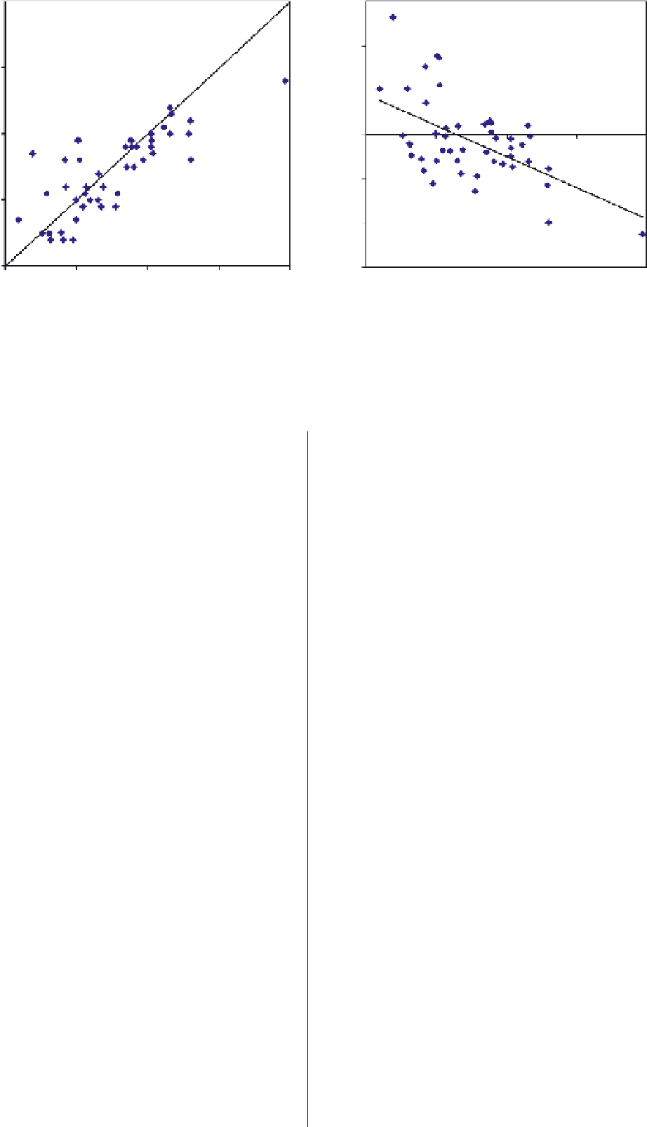
FIGURE 8.8
(a) Scatterplot comparing reference and modeled tree fractions; each point represents the mean tree cover
fraction for a neighborhood in South Denver (
n
47). The 1:1 line represents perfect agreement. (b) Plot of residuals (
modeled
- reference
) as a function of the reference fractions. The best-fit line indicates general trends of over- and under-estimation.
=
References
that facilitates spectral discrimination (e.g., Herold
et al
., 2004).
However, even with increased spectral resolution, some surfaces
are likely to remain confusing, such as dark, featureless surfaces
(e.g., asphalt roads and tar-shingled roofs), and highly reflective
surfaces (e.g., dry, sandy soil and concrete) (Herold
et al
., 2004;
Franke
et al
., 2009). One promising approach that addresses the
issues of spectral confusion and within-class variability in urban
landscapes is hierarchical (multilayer) MESMA. This method-
ology applies MESMA to multiple levels of class complexity,
from general categories (e.g., pervious or impervious) to spe-
cific urban material and vegetation species types. Hierarchical
MESMA incorporates the spatial dimension of imagery by using
the coarsest levels of analysis, associated with the highest degree
of confidence, to constrain the more complex levels (Franke
et al
., 2009). Use of MESMA to characterize urban land cover
across different levels of information will advance the develop-
ment of quantitative, generalizedmeasures needed to characterize
urban landscapes globally, while maintaining information on the
types and distributions of locally specific materials to support
urban planning and ecosystem management.
Adams, J.B., Smith, M.O. and Johnson, P.E. (1986) Spectral
mixture modeling: A new analysis of rock and soil at the
Viking Lander 1 site.
Journal of Geophysical Research
,
91
(B8),
8098-8112.
Adams, J.B., Sabol, D.E., Kapos, V.
et al
. (1995) Classification
of multispectral images based on fractions of endmembers:
application to land-cover change in the Brazilian Amazon.
Remote Sensing of Environment
,
52
, 137-154.
Adams, J.B. and Gillespie, A.R. (2006)
Remote Sensing of Land-
scapes with Spectral Images: A Physical Modeling Approach
.
Cambridge University Press, Cambridge.
Anderson, J.R., Hardy, E.E., Roach, J.T. and Witmer, R.E. (1976)
A land use and land cover classification system for use with remote
sensor data
, US Geological Survey, Professional Paper 964,
United States Government Printing Office, Washington, D.C..
Boardman, J.W., Kruse, F.A. and Green, R.O. (1995) Map-
ping target signatures via partial unmixing of AVIRIS data,
in
AVIRIS Airborne Geoscience Workshop Proceedings
.JPL
Publications, Pasadena.
Boucek, B. and Moran, E.F. (2004) Inferring the behavior of
households from remotely sensed changes in land cover: Cur-
rent methods and future directions, in
Spatially Integrated
Social Science
(eds M.F. Goodchild and D.G. Janelle), Oxford
University Press, Oxford, pp. 23-47.
Carlson, T.N. and Sanchez-Azofeifa, G.A. (1999) Satellite remote
sensing of land use changes in and around San Jose, Costa
Rica.
Remote Sensing of Environment
,
70
, 247-256.
Clapham Jr., W.B. (2003) Continuum-based classification of
remotely sensed imagery to describe urban sprawl on a water-
shed scale.
Remote Sensing of Environment
,
86
, 322-340.
DeFries, R.S., Townshend, J.R.G. and Hansen, M.C. (1999)
Continuous fields of vegetation characteristics at the global
Acknowledgments
The author is grateful to Dar Roberts, Philip Dennison and
Kerry Halligan, who have successfully transformed multiple
MESMA codes into a user friendly, open-source extension of
ENVI, known as ''Viper Tools'' and available for download
at http://www.vipertools.org. The author also acknowledges
Sharolyn Anderson for helpful comments on drafts of this
manuscript. Research in Rondonia was funded in part by a
NASA Earth System Science Graduate Student Fellowship, as
well as NASA Grant NCC5-282 as part of LBA-Ecology. Digital
videography was acquired as part of LBA-Ecology investigation
LC-07. The Landsat ETM
imagery was acquired from the Trop-
ical Rain Forest Information Center (TRFIC). The author also
thanks two anonymous reviewers for helpful comments.
+


Search WWH ::

Custom Search