Geoscience Reference
In-Depth Information
<OGRVRTDataSource>
<OGRVRTLayer name="sample">
<LayerSRS>EPSG:32629</LayerSRS>
<SrcDataSource>sample.csv</SrcDataSource>
<GeometryType>wkbPoint</GeometryType>
<GeometryField encoding="PointFromColumns"
ₒ
reportSrcColumn="false" x="field_1" y="field_2"/>
<Field name="description" src="field_3" type="String"/>
<Field name="comment" src="field_4" type="String"/>
</OGRVRTLayer>
</OGRVRTDataSource>
With the utility
ogr2ogr
we convert the virtual vector to a Spatialite vector that
we can re-label during the response design. One of the nice features of the Spatialite
vector format is that it supports multiple layers within the same dataset.
ogr2ogr -f SQLite sample.sqlite sample.vrt
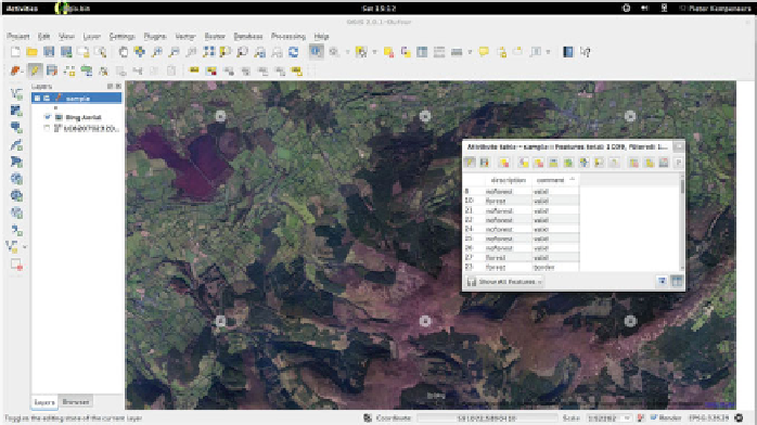
We open this vector in QGIS and overlay it to one of the image Web services from
the OpenLayers plugin (e.g. Google satellite or Bing Aerial) as shown in Fig.
17.6
.
With this layer we conduct a visual interpretation for each point. To update the
description field, open the attribute table of the vector layer and make sure to toggle
the editing mode. In addition to the description forest and non-forest, we can add a
comment to indicate problematic sample units. For instance, reference images can
be difficult to interpret due to cloudy or coarse resolution pixels. Another issue is
that reference sample unit can be at or near the edge of a forest. If this is the case, we
add the comment “border”. Otherwise, we set the comment to “valid”. This allows
Fig. 17.6
Labeling reference data via image interpretation in QGIS


Search WWH ::

Custom Search