Travel Reference
In-Depth Information
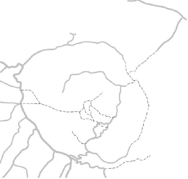
GUNUNG BATUR AREA
0
3 km
0
2 miles
WHEN TO TREK
The volcanically active area west of the main peak can be deadly, with explosions of steam
and hot lava, unstable ground and sulphurous gases. To find out about current conditions, ask
at the trekking agencies (see p243), or alternatively look at the website of the
Directorate of
Volcanology & Geographical Hazard Mitigation
(www.vsi.esdm.go.id)
.
The active areas are sometimes closed to visitors for safety reasons - if this is the case, don't try
it alone, and don't pay extra for an extended main crater trek that you won't be able to do.
Think twice about trekking in the wet season (October to March), because the trails can be
muddy and slippery, and clouds often block the views. Note that monsoonal rains often cause
landslides in some mountain areas.
A
B
C
D
INFORMATION
Pura Puncak Penulisan...............
10
A2
ATM............................................
Pura Ulun Danu Batur................
1
B4
11
C3
Bank BPD.....................................
2
A3
Tembok
1
Post Office...................................
3
A3
SLEEPING
Ticket Office................................
4
A4
Hotel Astra Dana........................
12
B4
Ticket Office................................
5
B4
Hotel Miranda............................
13
A3
Hotel Segara..............................
14
B4
Lupak
SIGHTS & ACTIVITIES
HPPGB Guides Office...................
6
C3
EATING
Pura Batur....................................
7
A3
Batur Indah................................
15
B4
Pura Bukit Mentik.........................
8
B3
Bumi Ayu...................................
Siakin
16
A4
Pura Jati.......................................
9
C3
Gunawan...................................
17
B4
To Siakin
(500m)
Gunung Penulisan
top for sunrise in the tourist season. Neither
is it necessary to be at the top for sunrise - a
halfway point is fine. If you start at 5am, you'll
avoid the crowds.
Guides will provide breakfast on the
summit for a fee (50,000Rp), and this often
includes the novelty of cooking an egg or
banana in the steaming holes at the top of the
volcano. There are several refreshment stops
along the way, but bottled beverages can be
pricey. Water sources may be dubious.
trekking, although the summit can still be OK
(see the boxed text, above).
Climbing up Gunung Batur, spending a
reasonable time on the top and then strolling
back down takes four or five hours; for the
longer treks around the newer cones, allow
around eight hours.
(1745m)
2
To Kubutambahan
Blandingan
(34km)
10
Penulisan
To Pelaga
(19km)
11
Songan
Toya Mampeh
Kintamani
13
2
Gunung Batur
FROM PURA JATI
A huge parking lot near Pura Jati makes this
the main entrance for groups and day-trippers.
The shortest trek is basically across the lava
fields, then straight up (allow about two hours
to the top). If you want to see the newer cones
west of the peak (assuming the area is safe to
visit), go to the summit first - do not go walk-
ing around the active area before sunrise.
8
(1717m)
3
7
See Toya Bungkah
Map (p247)
Kuban (Cemetery)
FROM TOYA BUNGKAH
The basic trek is to start climbing from Toya
Bungkah at about 3am, reach the summit for
sunrise, and possibly walk right around the
main cone, then return to Toya Bungkah. The
route is pretty straightforward - walk out of
the village towards Kedisan and turn right
just after the car park. After about 30 minutes
you'll be on a ridge with a well-defined track;
keep going up. It gets pretty steep towards
the top and it can be hard walking over the
loose volcanic sand. Allow about two hours
to reach the top, which is at the northern edge
of the inner crater.
Climbers have reported that they've easily
made the journey without a HPPGB guide,
though it shouldn't be tried while dark. The
major obstacle is actually avoiding any hassle
from the guides themselves.
You can follow the rim to the western side,
with a view of the area of the most recent
volcanic activity, continue to the southern
edge, and then return to Toya Bungkah by
the route you climbed up.
Longer trips go around the recent volcanic
cones southwest of the summit. This has the
Toya Bungkah
Batur
Trunyan
17
3
9
6
Kubupenelokan
Danau Batur
4
16
12
Abang
Gunung Abang
FROM THE NORTHEAST
The easiest route is from the northeast - that's
if you can get transport to the trailhead at
4am. From Toya Bungkah take the road
northeast towards Songan and take the left
fork after about 3.5km. Follow this small road
for another 1.7km to a badly signposted track
on the left - this climbs another kilometre or
so to a parking area. From here, the walking
track is easy to follow to the top, and should
take less than an hour.
17
14
(2152m)
Kedisan
15
4
Boat
1
Penelokan
Terminal
5
Buahan
Peludu
Beyunggede
To Suter (1km);
To Sekardadi (1km);
To Payangan (17km);
Tampaksiring (17km);
To Bangklet (7km);
Pempatan (11km);
Ubud (31km)
Bangli (18km)
Rendang (16km)
Ubud (29km)
Equipment
If you're climbing before sunrise, take a torch
(flashlight) or be absolutely sure that your
guide provides you with one. You'll need good
strong footwear, a hat, a jumper (sweater) and
drinking water.
Trekking Routes
The climb to see the sunrise from Gunung
Batur is still the most popular trek, even with
the high fees charged by, not to mention the
dodgy reputation of, the HPPGB; see p243.
Ideally, trekkers should get to the top for
for rates from about US$20 (not including
HPPGB fees); everything is negotiable.
Arlina's Trekking Agency
(Map p247 ;
%
51165;
Arlina's Bungalows, Toya Bungkah) Offers a range of treks.
Hotel Astra Dana
(Map p244;
%
52091; Kedisan)
Another recommended place.
Hotel Miranda
(Map p244;
%
52022; Jl Raya
Kintamani, Kintamani) One of the few agencies that will
take solo climbers.
Hotel Segara
(Map p244;
%
51136; hotelsegara@plasa
.com; Kedisan) Popular with larger groups.
Jero Wijaya Tourist Service
(Map p247 ;
%
51249;
jero_wijaya@hotmail.com; Lakeside Cottages, Toya
FROM KINTAMANI
From the western edge of the outer crater, trails
go from Batur and Kintamani down into the
main crater, then up Gunung Batur from the
west side. This route passes close to the rather
exciting volcanically active area and may be
closed for safety reasons. Check the current sta-
tus with the guide at Hotel Miranda (p246).