Geography Reference
In-Depth Information
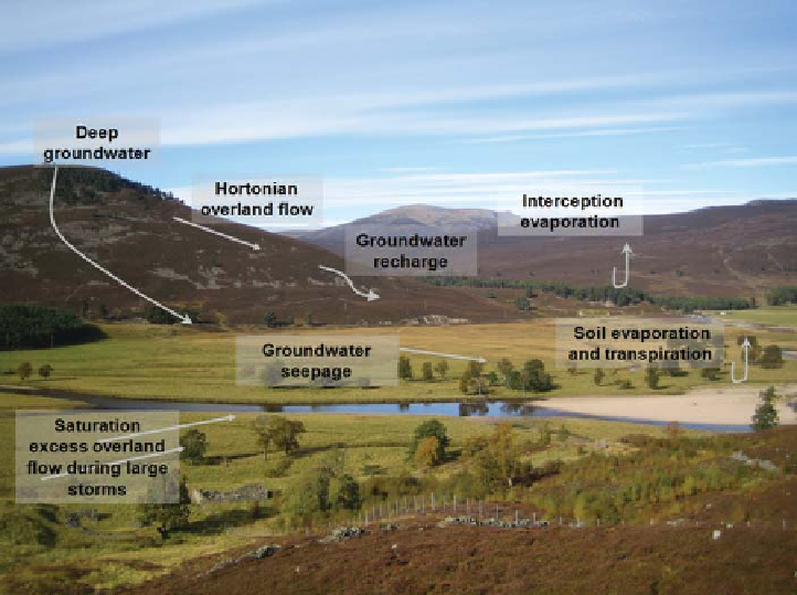
Figure 4.1. Different parts of the
landscape may be amenable to
different flow pathways. Example
from Alltachlair, the River Dee and
Beinn a Bhuird, with typical flow
paths to be expected in this type of
landscape. Photo: N. Corby.
their main direction, and thus accelerate the flows for a
given gradient; they organise the flows as they create
strong anisotropy in flow resistances and reflect the co-
evolution of the (sub-)surface, hydrological processes and
eco-system in the past towards a spatial organisation. In
general, subsurface flow can be shallow (close to the
surface in the soil) or deeper and occurs in the pore spaces
of porous media, such as soil or regolith, and in cracks or
fissures of the underlying bedrock. Which part of the given
set of morphologically connected flow paths is activated
depends on the supply of water as well as the presence of
stored water. Furthermore, it is important to note that each
flow path is active on a different time scale. Functional
connectivity of flow paths and thus hydrological connect-
ivity is thus dynamic, and changes with time.
Figure 4.1
shows examples of surface and subsurface flow paths that
can be active at a given location. Eventually, the water in
these flow paths emerges at a stream at the foot of a
hillslope or further downstream. It is these flow paths and
the storage capacities of the various landscape units present
that should ideally be identified in order to design a realis-
tic model of a given ungauged catchment. In other words,
it is crucial to identify the location, the time scales and the
threshold dynamics of the flow paths present in the catch-
ment (Zehe et al.,
2007
).
If the dominant flow paths together with their threshold
patterns, time scales and storage capacities are well char-
acterised a model has the potential to reproduce the catch-
ment response dynamics well under varying wetness
conditions. This has
estimation of the runoff signatures. For example, while
baseflows are mostly sustained by groundwater and its
seasonal fluctuations, peak flows are frequently controlled
by additional flow paths, which become gradually con-
nected to the stream with increased catchment wetness
and which are characterised by much shorter time scales
and lower storage capacities.
If information about flow paths and storage in a catch-
ment is known, it can be used in a number of ways to inform
the estimation of runoff signatures in ungauged basins.
Information on flow paths and storage can be directly
used in ungauged catchments to inform the choice of
model structure, constrain a-priori model parameters,
and thus to estimate runoff signatures.
Information on flow paths and storage can be used to
assist in transposing runoff signatures from gauged to
ungauged basins, e.g., by grouping catchments and land-
scape units according to similar flow paths and storage
characteristics.
Finally, information on flow paths and storage can pro-
vide guidance on the choice of model structure and
model parameters in gauged catchments. More realistic
model parameters and a more realistic model structure in
gauged catchments would then be expected to translate
into more reliable estimates of runoff signatures in
ungauged catchments.
Information about flow paths and storage can be obtained
either through a top-down approach or a bottom-up
approach. The top-down approach examines the collective
important
implications
for
the
Search WWH ::

Custom Search