Geography Reference
In-Depth Information
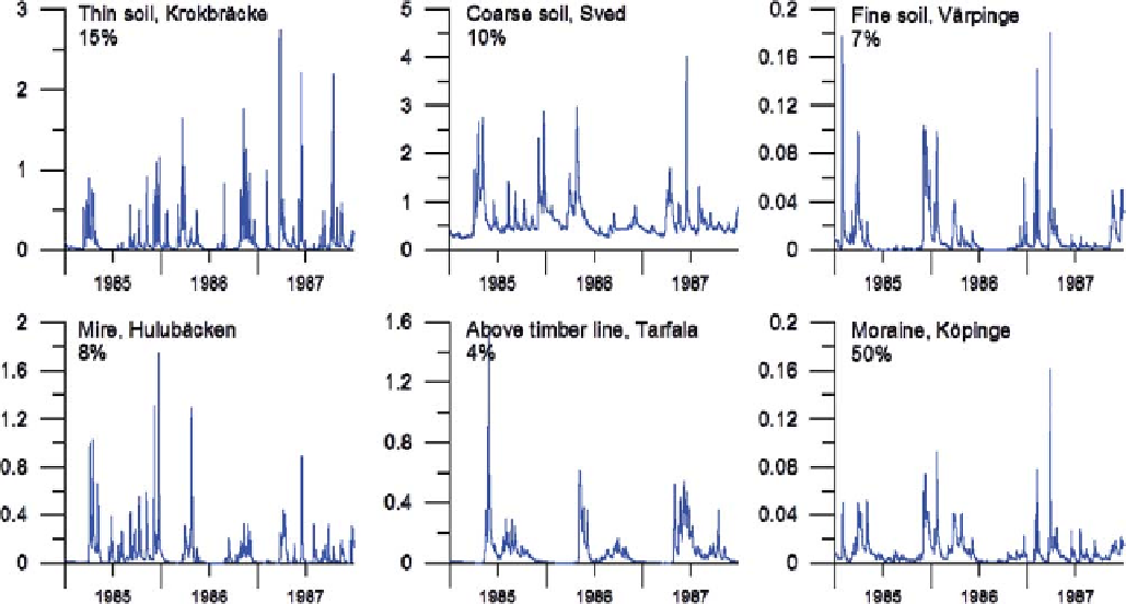
Figure 11.88. Observed hydrographs from some small Swedish catchments with different soil types. The percentages illustrate how large an area
of the total Swedish surface each soil type represents.
government to deliver high-resolution model predictions of
water and nutrients to water authorities, in order to support
their WFD work. The HYPE model is a dynamic, semi-
distributed and process-based model (see
Section 10.4.1
)
based on well-known hydrological and nutrient transport
concepts. In the model, the landscape is divided into
classes according to soil type, vegetation and altitude.
The soil representation is stratified, where the soil can be
divided into three layers. In order to be able to cope with
environmental issues, the flow paths include surface run-
off, macropore flow, tile drainage and groundwater out-
flow from the individual soil layers (see
Chapter 4
). Rivers
and lakes are described separately with routines for turn-
over and rating. Model coefficients are global, or are
related to specific characteristics of hydrological response
units (HRU), i.e., combinations of soil type and land use.
The hydrographs from small catchments in Sweden may
differ considerably due to differences in soil properties; for
instance, thin soils are characterised by quick drainage and
low baseflow, whereas coarse soils are characterised by
sustained baseflow (
Figure 11.88
).
The HYPE model was applied nationally across the whole
of Sweden (called S-HYPE) using a stepwise, multi-basin
calibration technique (
Donnelly et al., 2009
; Strömqvist
et al.,
2012
). In total, the HYPE model has many hundreds
of rate coefficients, constants and parameters, which in
theory could be adjusted. Most such values, however, were
estimated from literature values and fromprevious modelling
experiences (a-priori values, see
Section 10.4.3
). About 15
parameters for each land use and soil type and another 10
global parameters were regionally calibrated (see
Section
10.4.4
). The HYPE model is equipped with a Monte Carlo
routine, which was applied during the model development to
define the most sensitive parameters and parameter inter-
actions. The model was applied for a 20-year period using
a daily time step. The regionalisation method used for the
Swedish model application can be summarised as follows.
Overall water balance (see
Chapter 5
)
In the first S-HYPE setup (Strömqvist et al.,
2012
)the
overall water balance was first evaluated against meas-
ured long-term discharge volumes at 198 SMHI runoff
gauging stations (with a drainage basin area
2000
km
2
), which provided a good geographic coverage of
Sweden. The evaluation showed that the amount of pre-
cipitation in the mountainous area along the border with
Norway was underestimated. Since precipitation was
below the recorded discharge in some catchments, this
was clearly not a model error, and instead indicates that
the precipitation data set did not capture all precipitation
at higher altitudes. This is a well-known problem in
mountainous areas. The precipitation was therefore
increased by 10% in sub-basins above 400 m a.s.l. Water
balance evaluations also showed that discharge was
Search WWH ::

Custom Search