Geography Reference
In-Depth Information
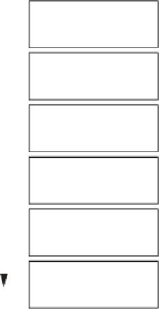
Figure 11.66. AGWA modules, and
the sequence of steps for
hydrological modelling and change
detection.
Watershed
Delineation
DEM processing, watershed delineation, and subdivision of
the watershed into model computational elements
Parameter
Estimation
Deriving relevant hydrologic parameters from land-cover and
soils data using provided (editable) look-up tables
Multiple options for both KINEROS2 and SWAT using
provided and readily available National Weather Service
(NWS) products
Generation of
Rainfall Input
Model
Execution
Building model parameter files, running the models, and
importing simulation results
Change
Analysis
Differencing results from multiple simulations based on
different land-cover or rainfall data to evaluate change
Results
Visualisation
Mapping the output of model simulations to visualise spatial
variability and identify problem areas
the study area and the overall study are available in Ken-
nedy (
2007
) and Kennedy et al.(
2012
).
the model elements are estimated within AGWA. AGWA
employs globally available digital geographic coverages of
soils, topography and land cover/land use.
2
The sequence of AGWA operations and initial parameter
estimation is depicted in
Figure 11.66
. After catchment
delineation and discretisation to define model element poly-
gons and their corresponding geometric parameters, the
model element polygons are intersected with soils and land
cover GIS layers to derive area-weighted averages of those
properties for each model element. Pedo-transfer functions
based on soil texture (Rawls et al.,
1982
) are used to define
initial model element infiltration parameters. Assuming an
average cover condition for each land cover/land use class,
hydraulic roughness is estimated (Chow,
1959
among
others). Trapezoidal channel morphology parameters are
estimated using multivariate regressions based on variables
derivable from the GIS coverages (Miller et al.,
2003
). If
observed precipitation is not available, AGWA can access
design storms from across the USA.
Method
The KINEROS2 model (Smith et al.,
1995
; Semmens
et al.,
2008
) was applied to these two catchments to test
the transferability of model parameters to any catchment
(see
Chapter 10
). The Automated Geospatial Catchment
Assessment (AGWA) tool (Miller et al.,
2007
) can be used
to set up KINEROS2, parameterise it with initial estimates,
execute the model, and display results spatially in a GIS
framework. In the parlance of PUB regionalisation, initial
model parameters were estimated by relating readily avail-
able basin characteristics (soils, topography, land cover/
land use) to values reported in field studies and literature
through the use of look-up tables in AGWA. KINEROS2
is an event-based distributed rainfall
erosion model
that represents a catchment as overland flow elements
(planes or curvilinear surfaces) draining into channel
model elements. The urban catchment was modelled with
the KINEROS2 urban element (Semmens et al.,
2008
;
Kenn
edy et al.,
2012
), a series of overland flow elements
intended to represent a contiguous row of residential lots
along one side of a street plus one-half of the street itself.
The urban element simulates runoff from impervious areas
directly connected to the street (e.g., roof to driveway to
street), runoff from impervious areas that flows over a
pervious area (e.g., roof to yard to street), and runoff from
pervious areas directly and indirectly connected to the
street. Both the geometric parameters (slope, area, flow
length, width) and the hydraulic and infiltration parameters
(roughness, porosity, saturated hydraulic conductivity) of
-
runoff
-
Results
It is instructive to examine the observed cumulative pre-
cipitation and runoff from the urban and grassland catch-
ments to see the profound impact of urbanisation (
Figure
11.67
). Total runoff from the urban catchment is 26% of
total precipitation; runoff from the grassland catchment is
just 1%. If KINEROS2 can effectively model the urban
2
For this study automatic parameterisation of the urban element by
AGWA as a function of zoning/housing density had not yet been
implemented and manual parameterisation was conducted.


Search WWH ::

Custom Search