Geography Reference
In-Depth Information
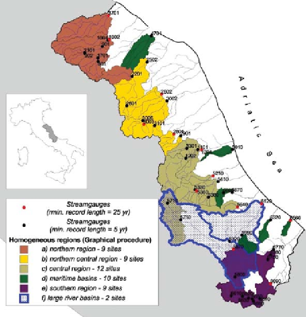
a) northern region - 9 sites
b) northern central region - 9 sites
c) central region - 12 sites
d) maritime basins -10 sites
e) southern region - 9 sites
f) large river basins - 2 sites
1
0.1
0.01
0.3
0.4
0.5
0.6
0.7
0.8
0.9
1
Duration
D
Figure 11.32. Study region and dimensionless flow duration curves (daily runoff divided by the long-term mean) for six homogeneous
sub-regions. From
Castellarin et al. (2004)
.
within a broad region of central Italy. The regional model
would then have been used in the context of hydropower
feasibility analyses to locate suitable sites (i.e., ungauged
basins characterised by suitable surface water availability
and runoff regimes). Also, the analysis was triggered by the
fact that at that time the literature reported a large number of
studies on FDC regionalisation, presenting several different
approaches to this problem (see also
Section 7.3
); neverthe-
less, no study compared the reliability of the different
regional approaches, and in fact the indications on the reli-
ability of any of these regional models for the prediction of
FDCs in ungauged sites were still very sparse.
monthly runoff during winter and the minimum during
summer, and (ii) the Apenninic regime, with two maxima,
a lower maximum during spring and a higher one during
autumn.
The record length at the gauges varies from a minimum
of 5 years to a maximum of 67 years with a mean value of
24 years. Several geomorphological and climatic charac-
teristics were determined for the 51 basins, such as
the basin area A, an estimate of the permeable portion of
the basin area A
P
, maximum H
max
, median H
med
, and
minimum H
min
, elevations in metres above sea level
Δ
H
min
, and the main channel length L.
An extensive collection of hydrological information
enabled the characterisation of the 51 river basins from a
climatic and litho-pedological point of view. The climatic
information was retrieved from an evenly spaced network
of 88 thermometric sensors and 337 rain gauges. The
monthly series of areal temperature and rainfall depth were
evaluated for each river basin through the use of the
Thiessen polygon method by referring to the thermo-
pluviometric data collected in the same time span as the
runoff observations. These measures were then utilised
to derive 51 values of the mean annual temperature T
A
,
mean annual precipitation P
A
, mean annual potential
H
¼
H
med
-
Description of the study area
Figures 11.32
and
11.33
illustrate the study region,
covering an area of 17 830 km
2
and 51 unregulated river
basins, which are characterised by the absence of diver-
sions, direct water abstractions, reservoirs etc. For these
51 river basins, daily runoff series observed within the
time span 1921
2000 are available from the National
Hydrographic Service of Italy (SIMN). The runoff regimes
of the study area can be roughly classified into two large
groups:
-
(i)
the maritime regime, with the maximum


Search WWH ::

Custom Search