Geography Reference
In-Depth Information
Study area
72°
70°
MAINE
WBWA
(011085800)
*
OYST
SOU1
(01073000)
WARN
(01089000)
(01086000)
NEW
HAMPSHIRE
COLD
BEAR
SAXT
VERMONT
(01155000)
43°
(01154000)
(01154000)
SBPI
NEW
YORK
CONT
(01091000)
EXPLANATION
State boundary
(01082000)
STON
(01093800)
BBNH
EMEA
GREW
*
(010965852)
(01100700)
(01333000)
NBHO
GREC
Catchment boundary
TARB
(01170100)
PRIE
*
(01332000)
(01161500)
SQUA
*
(01162500)
NORT
*
MOSS
(01096000)
Streamgauges least affected by regulation
(01169000)
(01165500)
DRYB
SOUT
(01331400)
Four-letter station code with U.S. Geological
Survey station number in parenthesis
HOPM
(01174000)
(01169900)
NASH
HOPM
(01097300)
(01174000)
WBSW
(01174565)
Streamgauge with more than 20 years of
observations that includes the drought-
of-record
Streamgauge with some observed record not
affected by regulation
SYKE
BOSTON
CADW
STIL
(01180000)
*
MILL
(01174900)
(01095220)
(01171500)
(01089000)
BASS
MASSACHUSETTS
OLDS
SEVE
GRGB
WBWE
*
(01105600)
(01175670)
(01198000)
(01198500)
(01181000)
QUAB
*
DORC
BLAB
(01107000)
(01176000)
IHEA
Validation streamgauge
VALL
*
NIPM
BRAN
*
(01105730)
(01187400)
(01111300)
42°
(01111500)
HUBB
*
(01187300)
STCT
TAU N
(01184100)
*
(01108000)
SALC
WADI
PEEP
(01199050)
(01109000)
(01109200)
(01115098)
(01115187)
WBPA
BURL
*
*
MOUN
PONA
(01188000)
(01121000)
RHODE
ISLAND
BLAC
HOPC
TENM
(01126600)
(01123000)
(01120000)
ADAM
(01200000)
*
LITT
NOOS
WOOA
(01106000)
(01115630)
SALR
*
WOOH
*
(01193500)
CONNECTICUT
*
PEND
BRRI
EBEM
(01118300)
(01118500)
(01194500)
PAW E
*
PAW R
*
INDI
(01117500)
(01195100)
0
50 KILOMETERS
http://pubs.usgs.gov/fs/fs09303/pdfs/fs09303.pdf
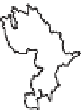
http://ma.water.usgs.gov/nwis/images/01105880.stream.jpg
http://ma.water.usgs.gov/nwis/images/01097300.jpg
Figure 11.24. Examples of hydrological settings and stream gauges used to estimate daily runoff time series at ungauged locations in the
north-eastern USA. Modified from Archfield et al.(
2010
).
flow needs of a basin should reproduce the
'
natural flow
water allocation decisions. An additional consideration for
the selection of the regionalisation method was the ability to
incorporate the methods into an easy-to-use decision-support
tool that required minimal training and resources. This con-
sideration ruled out the use of regionally calibrated rainfall
regime
, meaning that ecological flow needs should reflect
the magnitude, frequency, duration, timing and rate of
change that occurs naturally in runoff. Therefore, a constant
runoff target would not be adequate to fully characterise and
meet the ecological needs of a particular river and existing
low flow regional regression equations could not be used for
'
-
runoff models to determine water availability at ungauged
locations in the study area.


Search WWH ::

Custom Search