Geography Reference
In-Depth Information
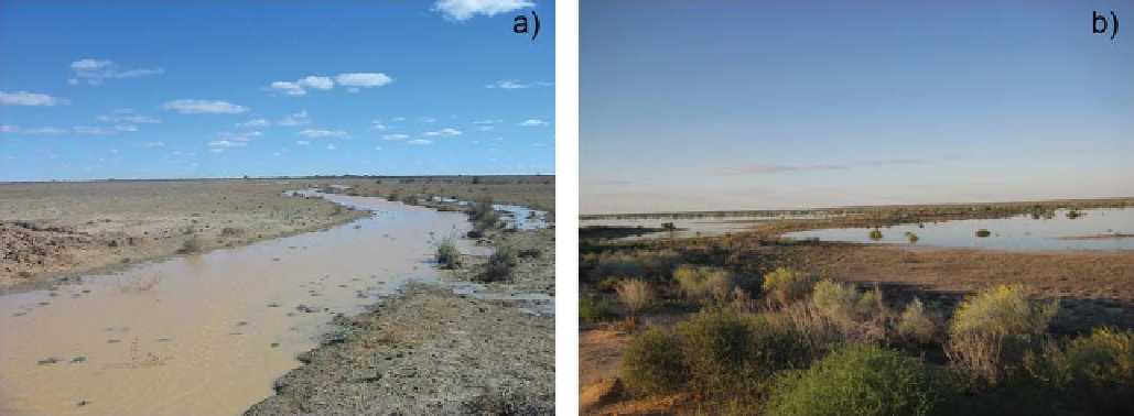
Figure 8.9. (a) Diamantina near Birdsville, at the forefront of a flow event that is beginning to spread out over a vast, poorly channelised
floodplain. (b) Lower Cooper near Callamurra showing low gradient floodplains with little channelisation. Photos: J. Costelloe.
concern with the regression approach is that the catchment
characteristics may be correlated, causing a redundancy in
information and leading to multi-collinearity. Multi-collin-
earity can cause the variance of parameter estimators to be
inflated, which may lead to apparently good model fits but
poor performance when applied to a validation data set.
Multi-collinearity can be checked by variance inflation
factors (Kroll et al.,
2004
), and dealt with either by princi-
pal component analysis (Demuth,
1993
) or by a stepwise
regression approach where only those catchment charac-
teristics that provide statistically significant information
and are independent from the other catchment characteris-
tics already used are included in the regression (Demuth,
1993
; Tallaksen and van Lanen,
2004
; Laaha and Blöschl,
2006a
). The stepwise approach is particularly useful if the
number of catchment characteristics is large (Kroll et al.,
2004
).
The choice of the catchment/climate characteristics
should always be guided by the understanding of the
hydology in the area (WMO,
2008
; DWA,
2009
). It is
therefore important to interpret the catchment/climate char-
acteristics that are found to be significant during a regres-
sion analysis from a hydrological perspective, i.e., to link
the statistical analysis to the hydrological processes oper-
ating at the catchment scale. Vogel and Kroll (
1992
) found
that, in central western Massachusetts, low flow statistics
were highly correlated with the product of catchment area,
average basin slope and baseflow recession constant, with
the baseflow recession constant acting as a surrogate for
both basin hydraulic conductivity and drainable soil por-
osity. In fact, hydrogeological indices, such as the base-
flow index and the baseflow recession parameter often
have high explanatory power (Demuth,
1993
; Tallaksen,
1995
; Kroll et al.,
2004
), but for ungauged basins they
need to be regionalised as well. Laaha and Blöschl
(
2006a
) found that precipitation, topography (slope and
elevation characteristics) and hydrogeological classes
were the most significant catchment characteristics.
Annual precipitation was particularly relevant through its
role of replenishing the water reservoirs. Vezza et al.
(
2010
) interpreted the regression coefficients between
low flows and catchment/climate characteristics in the
following way (
Figure 8.6a
):
in the
south-eastern
Apennine
Mediterranean part of the area (Group 1), the
elevation of the catchments is the relevant characteristic
because high elevation is related to low evaporation, more
precipitation due to orographic effects and late spring
snowmelt. Elevation is the main control also in the small
elevated highlands catchment in the north-west (Group 3),
where low flows are relatively low and occur in winter,
because of freezing processes that are more or less effect-
ive for different elevations. In the remaining Alpine range
(Group 2), low flows are higher (climate is wetter than in
the Apennine area and warmer than in the highlands),
they occur in winter and vary according to precipitation,
elevation (because of evaporation), catchment size
(because of interactions with aquifers) and land cover
(which controls evaporation, infiltration capacity and
recharge of groundwater systems). The interpretation of
these controls suggests that, in order to obtain plausible
regression models that can be used for extrapolation to
ungauged basins, it is essential to examine the sign and
relative magnitude of the coefficients hydrologically
(
Section 8.2
). Similarly, it is useful to check the results
of the regression model by leave-one-out cross-validation,
plot the errors on a geographic map and interpret them
-
Search WWH ::

Custom Search