Geography Reference
In-Depth Information
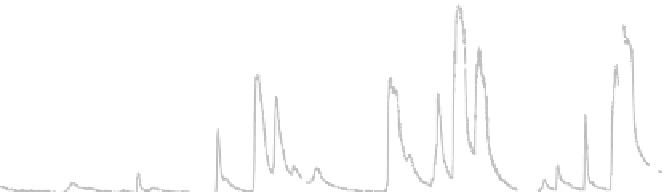
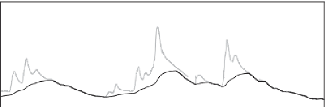
Figure 8.5. Hydrographs of daily
runoff and baseflow for (a)
Thompson River at Davis, Iowa
(1816 km²), and (b) Elkhart River at
Goshen, Indiana (1538 km²).
Baseflow shown as thick black line
calculated by digital filter.
12
a)
10
8
6
4
2
0
March 2011
April 2011
May 2011
June 2011
6
b)
5
4
3
2
1
0
March 2011
April 2011
May 2011
June 2011
Climate similarity
If no runoff data are available in a particular catchment,
similarity measures may be based either on climate or on
catchment characteristics. Important climatic characteris-
tics include long-term mean annual values of precipitation,
air temperature and the aridity index. Indices may also
include the seasonal distribution of these climate variables,
e.g., represented by monthly or seasonal mean values of
precipitation (see
Chapter 6
). The choice of the similarity
measures needs to be guided by knowledge of the low flow
processes. In arid climates, for example, many rivers regu-
larly dry out, and the low flow runoff of such rivers will be
zero. In monsoon areas practically all precipitation occurs
during a rainy phase of the year and low flow occurs at the
end of the post-monsoon recession period. Timing of cli-
mate characteristics is therefore an important similarity
parameter. If snow processes are involved, parameters
related to the deposition or melting of snow may become
very important. In alpine climates, low flow generation
processes may change with catchment altitude because of
freezing and melting, so altitude may be a relevant similar-
ity index.
landscape scale. Hydrogeological and soil classes from
thematic maps are usually used instead. Also, a number
of surrogate measures are used. Vegetation may be an
indicator of soil processes through co-evolution of vegeta-
tion, soils and geology. Vegetation may be obtained from
land cover classifications such as the CORINE (Coordin-
ation of Information on the Environment) data set pro-
gramme of the European Commission. Topographic
elevation may be a surrogate for a number of processes
including snow, geology, soils and length of the subsurface
flow paths. Which of the catchment characteristics are
most important for low flow regionalisation depends on
regional factors such as climatic and geographic condi-
tions, as well as on the particular low flow index to be
estimated (Demuth and Young,
2004
). Demuth and Young
(
2004
) reviewed catchment descriptors used in regional
low flow estimation models. In a case study across Europe,
Demuth (
1993
) showed that geology and topography were
key parameters for estimating low flow characteristics. In
fact, geology and topography are often interrelated as a
result of the co-evolution of climate, landscape, vegetation
and soils. Climate and catchment characteristics are used in
almost all low flow regionalisation methods.
Spatial proximity is a simple similarity measure used
sometimes, based on the rationale that catchments that are
close to each other may have similar runoff processes, and
thus a similar low flow regime, although this may not
always be the case because of small-scale geological het-
erogeneities. Proximity is used in low flow regionalisation
in three ways: (i) in geostatistical models where more
weight is given to nearby gauges than to distant gauges
Catchment similarity
Hydrogeological and pedological information may be
characterised by properties of the aquifers and soils such
as porosity, permeability, storage coefficient, transmissiv-
ity and hydraulic conductivity. In hard rock aquifers, the
locales of faults and interfaces between different geo-
logical units can be extremely important for low flows.
These parameters are usually difficult
to obtain at
the


Search WWH ::

Custom Search