Geography Reference
In-Depth Information
10.00
51
Cluster n. 1
Cluster n. 2
1.00
7
3
2
40
39
10
42
0.10
76
65
77
48
8
66
75
21
74
69
1
71
15
38
28
49
44
17
47
4
Cluster n. 1
73
26
45
59
60
52
25
62
24
30
72
50
70
0.01
27
85
20
67
19
78
57
16
35
84
83
0
82
18
79
63
14
1
10.00
32
64
31
6
46
89
88
34
86
94
54
23
37
56
43
80
55
90
5
91
41
68
−1
11
81
29
2
95
9
36
58
93
1.00
61
87
22
92
13
12
53
33
−2
−2
−1
0
1
2
0.10
Standardised min catchment elevation
Cluster n. 2
0.01
0.5
5
20
50
80
95
99.5
Percent of time exceeded
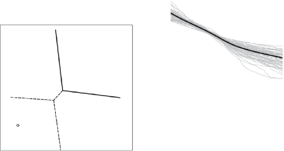
Figure 7.14. (Left) Non-contiguous regions in the space of catchment characteristics (standardised to have zero mean and unit variance).
The dashed lines represent the boundaries between the four clusters obtained before merging the clusters whose FDCs cannot be considered
significantly different. The final two disjoint regions are separated by the solid line. (Right) FDCs grouped by cluster (grey) and corresponding
regional curves (black). From Ganora et al.(
2009
).
parameters are needed to fit the observed distribution well
and it may be difficult to regionalise three or more param-
rescaled FDC methods is that there is no need to fit a
distribution function, but identifying a homogeneous group
may be more important. Also, the index flow (usually the
annual runoff) needs to be estimated in the ungauged
basin. Methods for predicting annual runoff are discussed
in
Chapter 5
.
interpolation (PSBI), or canonical kriging, and performs
the spatial interpolation of the desired characteristics of the
FDC in terms of geomorphoclimatic characteristics (Chok-
mani and Ouarda,
2004
; Castiglioni et al.,
2009
). The
second technique, named topological kriging or top-
kriging, is analogous to a spatial interpolation method for
runoff-related variables, which interpolates the runoff
value of interest (i.e., low flow indices, annual runoff
etc.) along the stream network by taking the area and the
nested nature of catchments into account (Skøien et al.,
These approaches are particularly appealing for predic-
tions in ungauged basins as they provide a continuous
representation of the quantity of interest along the stream
network (top-kriging), or in the physiographic space
(PSBI). Potential applications of these approaches include
the estimation of FDC in a region (see e.g., Skøien and
Blöschl,
2007
; Castiglioni et al.,
2009
). Some preliminary
studies show application of PSBI to the problem of FDCs,
where the analyses apply a three-dimensional kriging
7.3.3 Geostatistical methods
Recent studies have proposed several regionalisation
approaches that depend only partially on, if not dispense
with, the delineation of a homogeneous pooling group of
sites, which is a critical phase and a common prerequisite
for the application of FDC regionalisation approaches
(Grimaldi et al.,
2011
). These approaches apply geostatis-
tics criteria to the challenge of regionalising hydrological
information. The first is called physiographic space-based


Search WWH ::

Custom Search