Geography Reference
In-Depth Information
A1
200 km
B1
50
50
50
A1
A2
B1
40
40
40
30
30
30
A2
B2
C
20
20
20
10
10
10
0
0
0
J
MM JS
N
J
MM JSN
J
M
M
JSN
50
50
50
50
B2
C
D1
D2
D2
40
40
40
40
30
30
30
30
20
D1
20
20
20
10
10
10
10
0
0
0
0
J
MM
JS
N
J
MM
JS
N
J
MM
JS
N
J
MM
JS
N
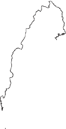
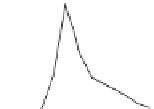
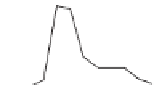
Figure 6.15. Hydrological regions of Sweden (left) and first empirical orthogonal function for each region (right). From Gottschalk
(1985)
.
resulting in the geographically contiguous groups shown in
Figure 6.15
.
groups could be classified as, for example, glacial moun-
tain sources of runoff with glaciers constituting more
than 2% of the catchment area (Duncan and Woods,
2004
). Each region had a characteristic flow regime.
The combination of climate and source of runoff was
then used to predict Pardé coefficients for all rivers in
New Zealand.
In contrast to statistical classification of the runoff
regime alone, the multiple kinds of physical and climate
data that can be used to characterise basins allow tech-
niques such as classification trees to be employed.
A classification tree tries to reproduce a flow regime clas-
sification, based on runoff data, in an attribute space
defined by measured catchment characteristics. Threshold
values are used to direct the classification approach: for
example, all Swiss catchments with a mean altitude
above 1500 m a.s.l. would be classified into one group
(alpine river regimes), all catchments at lower altitude
would be classified into another group. One goal of using
classification trees is to find simple ways to reproduce the
results of cluster analysis through a series of simple
Grouping based on catchment characteristics and climate:
non-contiguous regions
When formal statistical grouping techniques are applied
to either runoff data or to catchment characteristics,
the resulting groups are typically non-contiguous in geo-
graphic space. Although this leads to a spatially complex
prediction task, geographical independence of the clus-
ters ensures that they are not constrained to particular
spatial scales, but defined instead from physical and
climatic parameters (Snelder et al.,
2009
). The same
range of statistical techniques that are used to group
catchments on the basis of runoff characteristics can be
applied, instead, to physical and climatic data: distance
measures are now defined within a multivariate param-
eter space composed of the physically relevant catch-
ment descriptors.
These approaches can be used when the physical and
climatic factors used for analysis correspond well to the
variations in flow regime. Environmental regionalisation
principles (Bailey,
1995
), extended to account for net-
work conditions, climate, sources of runoff (including
'
'
yes/
no
decisions. However, identifying such algorithms has
proven challenging in practice (Haines et al.,
1988
). Clas-
sification trees can be extended to include regressions (see
Section 6.3.1
).
One of the challenges associated with using physical and
climate
'
)andeco-
logical characteristics, were used to map the rivers of
New Zealand (Snelder and Biggs,
2002
). The resulting
mountain
'
,
'
hill
'
,
low elevation
'
and
'
lakes
'
‛
characteristics
for grouping lies with their


Search WWH ::

Custom Search