Geography Reference
In-Depth Information
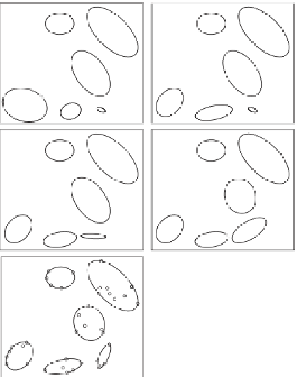
Figure 5.11. Cluster analysis in
Piemonte, Italy: Ward hierarchical
agglomerative algorithm and
reallocation rule. The similarity
metrics used for the classification are
catchment mean elevation and
longitude of the catchment centre
of mass. From Viglione (
2007
).
9
33
5
2
3
31
1
18
1
3
2
28
2
2
40
47
37
50
3
46
39
2
30
25
4
42
10
6
4
12
27
1
2
3
44
14
16
7
38
1
2
11
3
48
1
4
3
4
23
49
15
29
6
4
5
catchment mean elevation
this pattern recognition is done subjectively and the homo-
geneous regions are delineated manually on maps, choosing
their boundaries on the basis of geographic/hydrological
interpretation (see Tasker,
1972
; Choquette,
1988
; Jingyi
and Hall,
2004
). A drawback of this approach lies in the
quality of the initial model, i.e., residuals may be artefacts of
an unsuitable model rather than a reflection of localised
catchment characteristics.
Methods that, in principle, do not need subjective
reasoning are, for example, the cluster analysis methods
(see Kaufman and Rousseeuw,
1990
; Parajka et al.,
2010
;
Kingston et al.,
2011
). In cluster analysis, catchment/cli-
mate characteristics are used to automatically classify
catchments into similar groups by means of a clustering
algorithm. In reality, cluster analysis involves a number of
subjective choices (as evaluated by Bower et al.,
2004
).
For example, the selection of catchment/climate character-
istics to be used and their relative weighting are crucial
(Nathan and McMahon,
1990
). In addition, one has to
provide a way to set the final number of clusters, which
has to account for the trade-off between hydrological
homogeneity and the size of the group.
An example of cluster analysis is illustrated for a case
study in Italy in
Figure 5.11
. The Ward hierarchical algo-
rithm (Ward,
1963
) is used to classify catchments based on
two characteristics: the catchment mean elevation and lati-
tude of its centre of mass. The algorithm starts by assuming
that each site is contained within its own unique cluster.
The clusters are then progressively merged in a way that
minimises the information loss (see
Figure 5.11
, left),
where information is measured as the sum of squared
deviations of each site from the centroid of its cluster.
The Ward algorithm generates compact clusters with
evenly distributed elements. However, it does not allow
element reallocation, so the final configuration is not guar-
anteed to be optimal. Reallocation procedures can be
applied concurrently while clustering the sites. For
example, Viglione et al.(
2007a
) used a reallocation tech-
nique with the Ward algorithm in a regional analysis of
annual runoff in north-western Italy (
Figure 5.11
, right).
This reallocation guaranteed that every site lay closer to the
centre of mass of its cluster than to the centres of mass of
any other group. The final regions are contiguous based on
catchment characteristics (as shown in
Figure 5.11
, bottom
right), but are generally non-contiguous geographically
(see
Figure 5.16
for example).
The classification applied by Viglione (
2007
)(
Figure
5.11
) is based on two characteristics: the catchment mean
elevation and latitude of its centre of mass. These were
selected because of their correlation with the CV of annual
runoff (see
Section 5.3.2
) estimated through a statistical
method. One alternative to statistical methods for the selec-
tion of catchment/climate characteristics for grouping is
based on process understanding (as discussed in
Section
5.2.1
for annual runoff). The classification shown previ-
ously in
Figure 5.5b
, for example, grouped catchments on
the basis of seasonality in the relative phase of precipita-
tion and potential evaporation (Wolock and McCabe,


Search WWH ::

Custom Search