Geology Reference
In-Depth Information
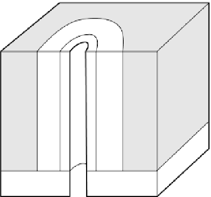
Sandstone
Borehole with drilling
fluid
Mudcake
Flushed zone
Annulus of invasion
Pristine formation
Shale
Fig. 11.1
The borehole environment.
instrumentation, including recorders, cable drums and
winches, is usually installed in a special recording truck
located near the wellhead. Sondes normally contain
combinations of logging tools that do not mutually
interfere, so that a wide suite of geophysical logs may be
obtained from a limited number of logging runs.
Several techniques of borehole logging are used
together to overcome the problems of mudcake and
drilling fluid filtrate invasion so as to investigate the
properties of the pristine wallrock. Open holes can be
surveyed with the full complement of logging tools.
Casing prevents the use of logging methods based on
electrical resistivity and distorts measurement of seismic
velocities. Consequently only a few of the logging
methods, such as those based on radioactivity, can be
used in cased holes.
Logging techniques are very widely used in the inves-
tigation of boreholes drilled for hydrocarbon explo-
ration, as they provide important
in situ
properties of
possible reservoir rocks.They are also used in hydrogeo-
logical exploration for similar reasons. A review of the
methodology and applications of borehole logging at sea
is given in Goldberg (1997). Some modern case histories
and reviews of recent developments are given in Lovell
et al
. (1999).
permeability, proportion of water and/or hydrocarbon
saturation, stratal dip and temperature.
Formation thickness and lithology are normally
determined by comparison of borehole logs with the
log of a cored hole.The most useful logs are those based
on resistivity (Section 11.4), self-potential (Section
11.6), radioactivity (Section 11.7) and sonic velocity
(Section 11.8), and these are often used in combination
to obtain an unambiguous section. The calliper log,
which measures changes in borehole diameter, also
provides information on the lithologies present. In
general, larger diameters reflect the presence of less
cohesive wallrocks which are easily eroded during
drilling.
Porosity estimates are usually based on measurements
of resistivity, sonic velocity and radioactivity. In addi-
tion, porosity estimates may be obtained by gamma-ray
density logging (Section 11.7.2), neutron-gamma-ray
logging (Section 11.7.3) and nuclear magnetic reso-
nance logging (Section 11.10). The methodology is
described in the relevant sections which follow.
Permeability and water and hydrocarbon saturation are
derived from resistivity measurements. Stratal dip and
temperature are determined by their own specialized
logs.
11.3 Formation evaluation
11.4 Resistivity logging
The geological properties obtainable from borehole log-
ging are: formation thickness and lithology, porosity,
In this chapter the symbol
R
is used for resistivity to avoid
confusion with the symbol
r
used for density.