Geology Reference
In-Depth Information
45
300
40
Native forest
Plantation forest
250
35
200
30
150
25
100
20
50
15
0
1234567891011121314151617181920
Year
10
5
0
0
1
2
3 4 5 6
7
8 9 1011121314151617181920
Year
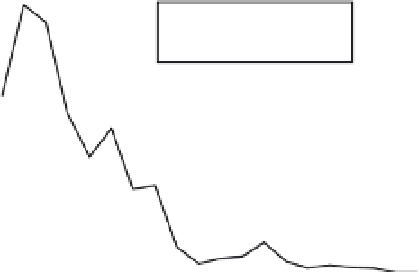
Fig. 14.7
Example of application to a hypothetical basin in Chile: comparison of mean monthly discharges and
(inset) annual sediment yields for covers of native forest and plantation forest over the 20-year plantation cycle.
Adapted from Bathurst
et al
. (1998c).
●
a protocol for using plot studies to quantify
model parameters and for applying the values at
different spatial scales; and
●
an emphasis on obtaining internal basin
response data, including sediment discharges,
gully growth and landslide inventories on both
event and long-term bases.
There are many areas in which model design
can be improved, from ever-more-detailed repre-
sentation of the process of raindrop impact ero-
sion to more efficient solution techniques.
However, there is still considerable scope for
integrating a wider range of the basic erosion
processes in a single model than is currently the
case. Some possible areas of advance are:
●
the incorporation of a gully erosion and sedi-
ment yield component;
●
the representation of linear features such as
roads and tracks;
●
the development of a sediment tracking capa-
bility, enabling sediment particles arriving at the
basin outlet to be related to their source areas
within the basin. This capability could be built
upon recent developments in tracking water
movement from source to outlet (O'Donnell,
2008) and could be tested using data on sediment
sources obtained by chemical 'fingerprinting'
techniques (e.g. Collins
et al
., 1997);
●
the coupling of a forest architecture and growth
model with a hydrological-geotechnical landslide
model, allowing feedback between forest growth
(including root systems and water demand) and
soil moisture content, with implications for over-
land flow transport of sediment and landslide
occurrence; and
●
the incorporation of the two-dimensional
rotational slip model for landslide simulation
(Collison & Griffiths, 2004). Current basin-scale
models typically employ the one-dimensional
infinite slope stability model because of its prac-
ticality but this restricts accurate representation
of slope conditions where groundwater flow or
topography produce forces that are significant in
directions other than slope-normal.