Geology Reference
In-Depth Information
(a)
(b)
1985-88
1970-79
2030-39
2090-99
1985
-
88
1970
-
79
2090
-
99
160.0
300.0
140.0
250.0
120.0
100.0
200.0
80.0
150.0
60.0
100.0
40.0
20.0
50.0
0.0
0.0
123456789 0 1 2
Month
123456789 0 1 2
Month
(c)
(d)
1985-88
1985-88 LU
1970-79
2030-39
2090-99
1985-88
1985-88 LU
1970-79
2030-39
2090-99
2.0
40
1.5
30
1.0
20
10
0.5
0
0.0
1
2
3
4
5
6
7
8
9 10 11 12
123456789101112
Month
Month
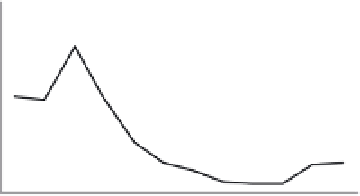
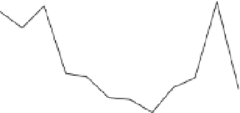
Fig. 14.5
Scenario simulations for the Agri basin in southern Italy. (a) Mean monthly rainfall for 1985-88
(measured) and three generated scenarios; (b) mean monthly potential evapotranspiration for 1985-88 (measured)
and the bounding generated scenarios; (c) mean monthly runoff and (d) mean monthly sediment yield simulated for
1985-88 with existing land use, 1985-88 with land use scenario (LU) and the three climate scenarios.
in the winter) and annual evapotranspiration
increases by 8% and 33% (most notably in the
summer). Consequently the simulated annual
runoff decreases by about 26% and 66% for the
two periods, and annual sediment yield decreases
by 14% and 32% (Fig. 14.5). The biggest changes
occur in the winter; the summer runoff is already
low and therefore unable to fall much further.
Tests showed some differences between the gen-
erated and measured rainfalls and potential eva-
potranspiration for the recent historical period,
and therefore the relative values arising from the
simulations are likely to be more reliable than
the absolute values. Nevertheless the results
indicate a capability for providing quantified data
of direct use in developing strategies to cope with
possible future change.
Bathurst
et al
. (2005) applied the full SHETRAN
sediment model, including landslide erosion, to
the 180 km
2
Valsassina-Esino basins in the Italian
Southern Alps. The model reproduced the observed
spatial distribution of landslides from a 50-year
record very well but overestimated the annual rate
of landsliding. Uncertainty bounds were derived
for the number of landslides: the upper bound con-
siderably overestimated the observed number but
was useful in visualizing spatial distribution,
while the lower bound was generally more repre-
sentative of reality (Fig. 14.6). Simulated sediment
yields could not be checked directly against
measured data but were within the range observed
in a wider region of northern Italy. The results
suggested, though, that the supply of shallow land-
slide material to the channel network contributes