Geology Reference
In-Depth Information
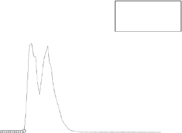
120
(a) Goomboorian
Oberved Q
Modeled Q
100
80
60
40
20
Fig. 11.6
A comparison of
measured and modelled
runoff rates at the
Goomboorian site.
Reproduced with permission
from Yu
et al
. (1997a).
0
0
20
40
60
80
100
Time (min)
to the time lag involved in overland flow moving
over the land surface to reach the exit from the
plot where runoff rate is measured. Yu
et al
.
(2000b) provided an analytical expression for this
lag time and illustrated its application. The effec-
tive value of Manning's
n
involved in this lag can
be evaluated from the lag between peaks in rain-
fall and runoff.
That such a three-parameter model of runoff
provides a very good description of runoff rate at
one-minute intervals within a storm event is
illustrated in Fig. 11.6.
results also provided a base against which the
soil-conserving effectiveness of alternative
management systems was compared. At each
site, soil, water and nutrient loss were recorded
for plots with different management scenarios,
firstly for the common farmer practice for the
crop of interest, and then for plots on which a
range of soil-conserving practices was imple-
mented. These practices were judged by collab-
orating scientists in the countries concerned to
be potentially effective, realistic in terms of adop-
tion feasibility, socially acceptable by land users
in the various regions of Asia and Australia, and
economically justifiable. All the soil-conserving
technologies investigated were agronomic and not
structural in character. At each site, agronomically-
based systems of cultivation have been confirmed
to yield generally low levels of soil loss, even on
steep slopes. Rose (1995) described some of these
management systems and the results obtained
with these systems in place.
As an example, at the Los Banos site in the
Philippines, the traditional farmer practice
involved up-and-down slope tillage prior to plant-
11.6.5
Some soil conservation outcomes
of ACIAR Projects
Results from the extensive ACIAR experiments
given earlier have focused on soil loss from the
bare-soil treatments included at each site, and
the interpretation of the data in terms of the
soil erosion parameter
b
using program GUEST.
With two exceptions, results from the bare soil
plots at all ACIAR sites showed unacceptably
high erosion losses of over 100 t ha
−1
y
−1
. These