Geology Reference
In-Depth Information
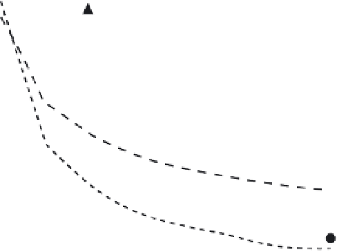
0.006
1.2
Mean erosion with the decrease of DEM
resolution only
Mean erosion with the decrease of both
DEM and vegetation cover resolution
Slope
1
0.005
0.8
0.004
0.6
0.003
0.4
0.002
0.2
0.001
Fig. 6.2
Sensitivity
analysis of a simple
Musgrave-type erosion
model to scale of
parameterization (after
Zhang
et al
., 2002).
0
0
0
10
20
30 40 50
Spatial resolution (minute)
60
70
80
90
this decrease was due both to mean slopes decreas-
ing with pixel size, but also to an averaging effect
of estimated vegetation cover (Fig. 6.2). Zhang
et al
. used an approach to scale the results that
considered the reasons why different parameters
change with data resolution. In the case of slope
angle, slope decreases with pixel size because
extreme values are successively less likely to be
sampled. The extent to which this occurs is
related to the local fractal dimension of the topog-
raphy, so that it is possible to define slopes at one
scale as a function of slopes at another scale using
the fractal dimension as a physically meaningful
scaling parameter (see also Zhang
et al
., 1999). To
scale vegetation cover, it was observed that fre-
quency distributions of vegetation cover within a
pixel undergo large but predictable changes as the
pixel size changes. These changes can be approxi-
mated using a Polya distribution function, whose
parameters can be estimated by building data-
bases of vegetation at different resolutions for dif-
ferent conditions. Finally, as total erosion is
strongly dependent upon individual events, but
large-scale data on events are not generally avail-
able, Zhang
et al
. (2002) used a statistical model
of runoff events as the basis of scaling the esti-
mated overland flow at a finer temporal resolu-
tion. This case study illustrates the importance
of process-based representations of parameters
and their changes with scale, with even very sim-
ple representations of the erosion process as
described in the Musgrave-type model.
A further methodological scaling problem is
that all process parameterization is to some
degree spatially lumped (at the measurement
scale) in a way that may fail to reflect the spatial
variability within a cell, and may have a signifi-
cant impact for modelling soil erosion (Canfield
& Goodrich, 2006). Consequently, process param-
eterizations that are used in high-resolution mod-
els at the plot scale (Wainwright
et al
., 2008b)
may not be applicable for larger cell sizes (but see
Section 14.7.1). In certain environments this
assumption may hold when cell sizes are of a
similar value to the widths of overland-flow
paths. However, as cell sizes increase, the topo-
graphic information that determines overland-
flow depth distribution is lost; flow depth is