Environmental Engineering Reference
In-Depth Information
(Fig.
1.4
d). On June 2, 2010, surface oil was observed 160km SWof Tampa, Florida.
The LCSs corresponding to this day indicated that the transport barrier was broken
and closer to the shoreline on the West Florida Shelf (Fig.
1.1
), which partly justified
the presence of oil in this area. The LCR was shed and remained unattached from
the LC at the surface until approximately June 14, 2010. Surface drifter trajectories
confirmed that therewas no surface connectivity between the LCRand the LC. During
one hydrographic cruise, four surface drifters were deployed at approximately 84
ⓦ
W
26
ⓦ
N, outside the LC and LCR system, where tar balls had been observed. Their
trajectories crossed the region between the LC and LCR at 84.5
ⓦ
W 24.5
ⓦ
N on June
13, 2010, (Fig.
1.8
), providing an indication that these two features were probably
not connected, and that there was no direct connectivity between the LCR and the
LC, at least at the surface. However, by June 15, 2010, the LCR had reattached to the
LC, as observed by altimetry (Fig.
1.4
e) and SST observations. Consequently, from
June 13-28, 2010, there was a direct path of waters from the anticyclonic ring into
the LC.
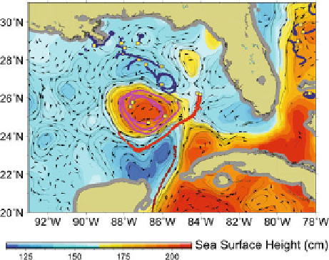
Satellite-tracked surface drifting buoys trajectories (Fig.
1.8
) were used to assess
the upper ocean circulation in the area of the spill, the shedding of the LCR from the
LC, the circulation of the LCR, and the cyclonic circulation located to the northeast of
the LCR (Fig.
1.1
) that was partly responsible for advecting surface oil to the south-
east during May and June (Figs.
1.4
c, d and
1.7
a). On June 28, the warm anticyclonic
LCR started to detach for a second time (Fig.
1.4
f). This LCR remained detached
Fig. 1.8
Surface trajectories (coloured lines) of satellite-tracked drifting buoys (“drifters”) between
June 8-16.
Red lines
correspond to four drifters deployed during the Walton Smith research cruise
[
30
] that served to assess the connectivity between the Loop Current and the Loop Current ring.
Purple lines
correspond to drifters that were used to monitor the circulation in the interior of the
Loop Current eddy.
Black lines
correspond to drifters that served to monitor the ocean circulation to
the northeast of the Loop Current ring. The background colours correspond to the altimetry-derived
sea surface height while the
arrows
represent current vectors computed from the sea height field
for June 13, 2010

Search WWH ::

Custom Search