Environmental Engineering Reference
In-Depth Information
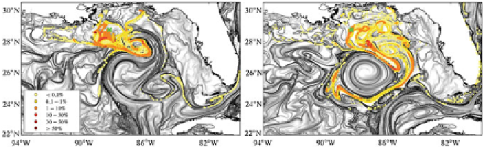
Fig. 1.1
Finite Time Lyapunov Exponents fields used to evaluate the path of particles at the surface
for the ocean surface conditions on (
left
) May 20 and (
right
) June 2, 2010. Convoluted bands of
most intense
black tones
indicate attracting Lagrangian Coherent Structures, which delineate the
pathways of the particles. In a numerical experiment, 10,000 water particles were released daily
near the location of the Deepwater Horizon oil well starting on April 20 and finishing on (
left
)May
20 and (
right
) June 2, 2010. The water particle density denoted by colours
yellow
(low values) to
orange
(higher values) is expressed as percentage of the daily discharge in 1/25
1/25 bins. No
particles were found to enter the West Florida Shelf and only a minimal fraction entered into the
Loop Current and Florida Current systems
×
mapping of mesoscale features present in the GOM, which are frequently observed
along the periphery of the larger features, including the LC. The complex surface
current field, which could not be measured by one satellite alone, necessitated con-
tinuous monitoring of the highly variable dynamic conditions of the upper ocean
and was accomplished by using a combined analysis of satellite together with in situ
observations and numerical modelling.
This work shows the importance of a combined analysis of observations and
numerical modelling. The goal of this chapter is to present results obtained from this
combined analysis on the link between the variability of the surface oil extent with
synoptic surface ocean currents and winds during the DWH event. This chapter is
organized as follows. The data and methods used to identify surface oil and surface
currents are presented in Sect.
1.3
. Results obtained from a suite of hydrographic
and satellite observations and from numerical models outputs are shown in Sect.
1.4
detailing the evolution of the LC system during April-August 2010 from satellite
fields that were used to identify the main ocean features and to explore potential links
between ocean dynamics and the oil spill extent. Section
1.5
summarizes the main
conclusions of this chapter.
1.2 Upper Ocean Dynamics in the Gulf of Mexico
The upper ocean circulation in the GOM is characterized by the excursions of the
LC, which irregularly sheds anticyclonic rings that travel in a northwest direction
into the GOM. The LC forms an intense anticyclonic flow, which expands north
westward [
9
] and can extend northward into the GOM to 28
ⓦ
N, in the vicinity of the
Search WWH ::

Custom Search