Agriculture Reference
In-Depth Information
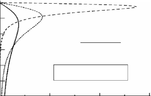
soil surface
0.00
0.25
0.50
operating frequencies:
Veris 150 Hz
EM 38 14500 Hz
0.75
1.00
responses are normalized to represent
a unit of area between every curve
and the ordinate
1.25
1.50
0
2
4
6
relative response, without dimension
Fig. 5.6
Relative response of conductivity sensors as a function of depth. For details to the imple-
ments Veris and EM 38 see Figs.
5.3
and
5.4
(From Sudduth et al.
2005
, altered)
The objective should be to have a depth weighted sensed area that approximately
incorporates the maximal root expansion during the growing season of all crops
within a rotation. Since principally several possibilities exist for adjusting the sensed
depth, it should at least roughly be tried to get the sensed vertical cross-section
adapted to this. However, going beyond the maximal root depth probably is less
disadvantageous than falling behind it, since during dry periods some water is
sucked from deeper horizons to the roots.
Important is also that sensing along a defined response curve pretends a uniform soil
electrical conductivity within the respective vertical cross section for the whole field
because the sensed signals are
integrals
. A soil with uniform properties within the verti-
cal cross section on the one hand and another one that is composed of different layers
within the sensed section on the other hand can result in the same integrated signal.
So sensing along a single defined response curve is a sensible and target-oriented
procedure only with soils that have uniform properties within the rooted depth. This
method can be misleading with
layered soils
since no depth resolution is delivered.
And there are many soils that have special layers or horizons within the subsoil. One
the one hand, these layers may prevent the drainage of water when they consist of
dense claypans or similar gleysolic, hydromorphic horizons. On the other hand,
there may exist layers that let seep the water too fast and hence do not store enough
of it because they are made up from coarse sand and gravel. And all layers may not
be positioned parallel to the soil surface. So in a three-dimensional analysis, there
can be a variety of different soil conditions.