Agriculture Reference
In-Depth Information
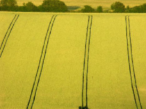
Fig. 4.1
Tramlines in small cereals (From UK Agriculture
2013
)
where during fertilizing and spraying operations the wheels of the machines go.
This allows for a better aligning during in-season fertilizing and spraying, provided
the operating width is an integer multiple of that of sowing. When tramlines cannot
be used - as with cultivating, sowing or for all operations on permanent grasslands -
either disc- or foam markers can assist in guiding the driver. With harvesting
machines, mechanical feelers that slide along the still standing crop can control the
guidance (Fig .
4.1
).
Yet an accurate guidance for all fi eld operations can be achieved on the basis of
georeferencing by
global navigation satellite systems
(GNSS)
. Via special com-
puter programs, these systems make it possible to guide machinery precisely along
virtual tramlines
while respecting boundaries that result from headlands or grassed
waterways even in irregularly shaped fi elds. The boundaries can be georeferenced
in a prior, circuitous pass around the fi eld. Once stored and mapped, they are avail-
able for several years.
The positioning information is provided either by differential GPS operating
with carrier phase signals plus dual frequencies or by real-time kinematic differen-
tial GPS (Table
3.4
). With manual- as well as with automatic steering, the start of
the satellite based guidance is either along a prior pass- or along a fi xed line.
With
prior pass guidance
, each run across the fi eld follows the respective prior
path offset by a given distance. Typically, this distance is the operating width of the
machine. The driver starts by manually steering the machine just as usual on a fi rst
path - a so called guess row - along the fi eld. This method is naturally used when the
driver starts operating,
e.g.
along a waterway or along an irregular- or curved fi eld
boundary. Once the prior pass has been recorded, all other trips across the fi eld
follow on the basis of GNSS. The courses of all passes are georeferenced in order to
get the following run. This method allows for adapting to fi eld shapes. Yet limitations
can arise because the following paths can end up with successively more bent curves.