Agriculture Reference
In-Depth Information
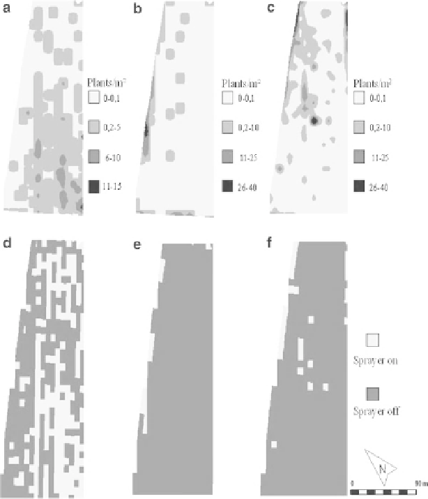
Fig. 10.1
Distribution of different weed species (
a
-
c
) in a 3 ha spring barley fi eld in the year 2003
and application maps as a decision rule for the patch sprayer (
d
-
f
). Maps were created according
to economic weed thresholds for all three weed species classes (Gerhards et al.
1997
)
Different methods to continuously record in-fi eld variation of weed distributions
were to surround and record the borders of aggregated patches of weed species such
as wild oats (
Avena fatua
) using a data logger connected to a differential global
positioning system (DGPS) (Colliver et al.
1996
) or to map weed patches during
harvest operations (Barroso et al.
2005
).
A major step towards a practical solution for site-specifi c weed management
was the development of sensor technologies and of differential global positioning
systems (DGPS) to automatically and continuously determine in-fi eld variation of
weed seedling populations
. Airborne remote sensing was found to be capable for
detection of high density weed patches of wild oats (
Avena fatua
L.) and of sterile
oats (
Avena sterilis
ssp.
ludoviciana
Durieu) in wheat as well as of infestations
of perennial weed species (Lamb and Brown
2001
). However, weed seedling