Geography Reference
In-Depth Information
TYPES AND FUNCTIONS OF CARTOGRAPHIC REPRESENTATION IN
NON-BINDING PLANNING INSTRUMENTS
In the context of ongoing European integration, there is growing interest in the creative
expression of normative concepts both within EU member states and at transnational
and EU levels, and it is recognised that this requires different approaches to carto-
graphic design from visualisations in binding plans at regional or local levels. Since the
early 1990s, consequently, there has been some more interest in planning cartogra-
phy at national or supranational scale. However, reflecting the relatively recent interest
in strategic planning at higher spatial scales, there is little previous work that attempts
to theorise the role of cartographic representations in informal planning. Literature and
recent experiences with informal planning instruments and planning cartography will
therefore be reviewed in this section in order to try and conceptualise the function of
cartographic representations in planning at this level of scale.
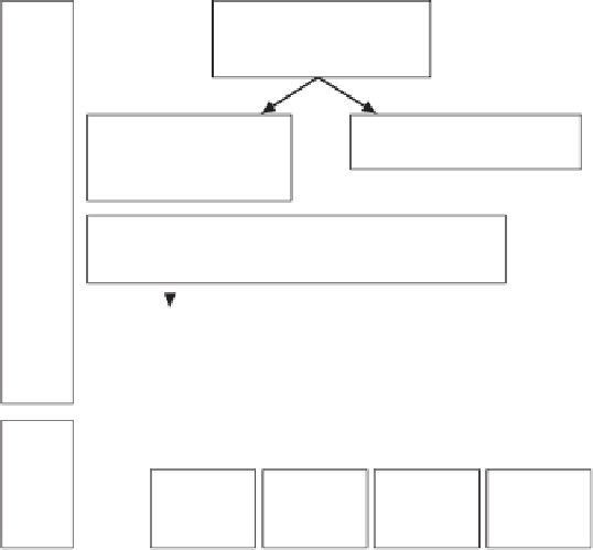
The method of developing spatial scenarios is increasingly used as a basis
for the preparation of informal planning strategies at higher spatial scale, such as
spatial visions, guiding principles or
Leitbilder.
Yet, owing to the relatively recent
increase in use of these instruments, the process of their preparation and the link
between the different instruments has not been clearly discussed in the literature
to date. On the basis of the literature review, the relationship between these infor-
mal planning instruments can be conceptualised as set out in Figure 3.4. The term
Trend scenarios
(prospective)
(explorative)
Strategy scenarios
(proactive)
(normative)
Alternative scenarios
Scenarios
prepared
by academics
Scenarios
prepared by public administration
Leitbild
guiding principle
(normative strategy scenarios)
'Spatial vision'
(alternative strategy scenarios)
Vision as
master
plan
Vision as
truth
Vision as
mission
statement
Vision as
utopia or
dystopia
Figure 3.4
Conceptualisation of the relations between spatial scenarios, spatial visions and
Leitbilder