Geography Reference
In-Depth Information
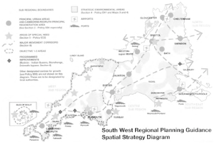
Spatial Strategies (RSSs) were chosen for analysis, i.e. RPG 1 for the North East
(GONE, 2002), RPG 10 for the South West (GOSW, 2001) (Figure 4.5) and draft
RPG 14 for the East of England (EERA, 2004) (Plate 10). In line with the require-
ments set out in PPG/PPS 11 on Regional Planning/Regional Spatial Strategies,
and PPG/PPS 12 on Development Plans/Local Development Frameworks, the key
diagrams in all documents are all strictly diagrammatic and schematic in style to
avoid clear locational references. Also in line with the guidance, the legend of the
key diagram includes a cross-reference to the written statement of policies.
THE GRAPHIC STRUCTURE
THE LEVEL OF ABSTRACTION/GENERALISATION
In this section, the level of abstraction of cartographic representations in strategic
spatial plans in the three countries is discussed according to the criteria set out in Box
4.1. The analysis reflects the indicative nature of strategic planning documents in the
Netherlands, with rather general and abstract representations (Figure 4.6). There is
much flexibility in the Dutch planning system that allows provinces to choose whether
to prepare a strategic planning instrument and which form it might take, and this flexi-
bility is reflected in a non-standardised approach to the illustration of spatial policy.
In German strategic plans there is a clear difference between the informal
ORA
and the binding (on public authorities) plans at
Länder
and local level (Figure
Figure 4.5
RPG 10 Regional Planning Guidance for the South West, spatial strategy diagram
Source: GOSW (2001: front inner cover), original A4