Geoscience Reference
In-Depth Information
8.4
Climate Change Impact on Lake Ice Season
8.4.1 Background Physics
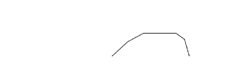
The principal seasonal ice characteristics are ice phenology, ice coverage, and ice
thickness. Figure
8.14
shows a schematic picture of the evolution of an ice season. Ice
grows slowly until mid-winter, and the melting in spring is fast. In the early and late
winters there are periods when the ice is still weak and maybe broken by winds, shown as
the unstable periods. In the stable phase, the ice cover is safe to walk and drive on, and its
presence is useful to the community. If climate warms, the stable period becomes shorter,
and the whole ice season may
finally become unstable.
Ice phenology includes the dates of freezing and ice breakup; also in large lakes the
period of full ice coverage and in very shallow lakes also the period of total freezing of the
water body are accounted for. Ice time series analyses and mathematical models have been
utilized to examine the sensitivity of ice season to climate and the expected changes in ice
seasons for various climate scenarios. Simple analytical models (e.g., Lepp
ä
ranta 1993,
2009a) can be used to provide the
first-order predictions, and numerical models provide a
better accuracy and more details about the ice cover structure.
Ice formation is generally governed by the intense radiative and convective heat loss
from the warmer lake surface to the colder atmosphere. Convection and wind-driven
mixing cool the water body to temperature below the temperature of maximum density,
and then (in freshwater and brackish lakes) the lake surface layer becomes stable and the
inverse thermocline develops. Surface cooling rate increases, especially at low winds, and
the surface temperature quickly achieves the freezing point, followed by ice formation.
Hence, the timing of freeze-up is strongly dependent on synoptic conditions
—
passages of
cold air masses and strong winds
over the lake. Ice formation is generally correlated
with synoptic variables, such as the local air temperature and wind, and is strongly
dependent on the depth of the lake. The relation between freeze-up and air temperature is
complicated since surface water temperature comes out from past air temperatures
—
filtered
with decreasing weights toward past and with memory time scale proportional to the depth
of the lake or the depth of the mixed layer (see Sect.
7.1.3
).
Fig. 8.14
A schematic picture
of the course of a lake ice
season
H = min thickness for stable ice,
10 cm (small lakes)-
50 cm (large lakes).


Search WWH ::

Custom Search