Geoscience Reference
In-Depth Information
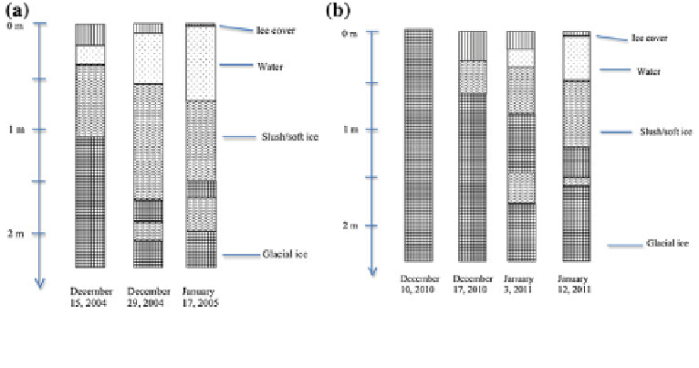
6.3.2 Structure of Supraglacial Lakes
Supraglacial lakes were investigated in two summers in the western Dronning Maud Land
by Lepp
ä
ranta et al. (2013b). The surface area of the main study lake, Lake Suvivesi (73
°
S
W, altitude 200 m), was about 7 km
2
at maximum, and the evolution of its vertical
extent can be summarized as follows (Fig.
6.6
). The lake starts to form in the solid ice
sheet in the beginning of December. From about the 10th of December the lake could be
utilized for liquid water supply in the nearby Aboa research station (the water usage was
about 1 m
3
/day, pumped from one hole in 15 min). The timing of the birth of the lake has
a very small interannual variability, less than 10 days.
At the initial stage, Lake Suvivesi appears patchy. Due to the positive albedo feedback
mechanism, the patches expand laterally and vertically, and thereby the lake achieves
more integrity. In the peak of the summer, mid-January, there is a 0
13.5
°
10 cm thick ice cover
on top, and the lake body extends down to about 200 cm depth consisting of two layers
(Fig.
6.6
). The main, upper layer is mostly liquid water and extends down to the depth of
½
-
-
ed and contains slush and hard ice layers. The deepest
layer is a slush layer with gravel and soil sediments. The source of this sediment is most
likely the neighbouring nunatak. The lake is thus not a continuous body of liquid water
but an ice
-
water mixture, which can be described by porosity
m
equal to the relative
volume of liquid water in a volume element. When
1 m. The lower layer is strati
m
[
m
0
, the ice loses its integrity and
the element turns into slush. Therefore, the lake boundaries can be de
ned by
m
[
m
0
(Lepp
ä
ranta et al. 2013b). The boundaries appear as an
'
ice bog
'
zone from the lake main
body to the solid ice sheet.
After the summer peak, the surface ice layer starts to strengthen but the radiation balance
is still positive and the main body of the lake continues to grow. The
field data did not cover
beyond February 1st, and it is not exactly known when the lake shrinking by freezing
Fig. 6.6
The vertical profile of Lake Suvivesi in
a
December 2004
-
January 2005 and
b
December
2010
-
January 2011 (Lepp
ä
ranta et al. 2013b)

Search WWH ::

Custom Search