Environmental Engineering Reference
In-Depth Information
During more than three centuries these two
problems lead to 16 unsuccessful attempts to find
it, equivalent to the same number of la Palma
native generations that grew up since the spring
disappeared in the 17th century.
solving the first problem -to determine where
it was buried- was compensated with the free
interpretation of four stages that were conveyed
from parents to children in the search of a cross
that apparently marked the place of burial. each
attempt was believed to be the actual site where it
lay buried and the mouth of a well was marked.
at that moment the second problem was encoun-
tered: how to excavate through a soil constituted
by stones not bigger than a boulder with any cohe-
sion at all.
Right from the beginning the walls started col-
lapsing toward the center of the excavation leaving
in bare equilibrium the rest of the embankment that
threatened to bury the workers as they dug deeper.
all of the attempts had to be abandoned due to the
unstable nature of the excavated walls and it was
hardly possible to reach no more than one tenth of
the depth required to encounter the sea level.
But this was no reason to continue trying, fail-
ure after failure, in the course of time but Fuente
santa remained buried. illustrious la Palma
inhabitants took part in those attempts, such as
Juan Pinto de Guisla, Juan de Paz, Manuel Díaz
hernández, Juan antonio Pérez Pino, luciano
hernández, and Pedro Pérez Díaz, as well as con-
tinental geologists and engineers such as lucas
Fernández navarro, enrique Godet, Juan Gabala,
and Juan a. kindelán, and foreigners such as
antonio Joseph Palmerini and leopold von Buch.
not all of them were material attempts but also the
demands of islanders to recover the Fuente santa
arouse the interest of writers such as Viera y clav-
ijo, alexander von humboldt and more recently,
the unequaled prose of Dulce María loynaz.
where we could learn about this history, a common
one for mankind: the longing of people to recover
a lost property. We surveyed the volcanic malpais,
looking for something that we actually ignored,
among other things the cross identifying the site.
The land to be surveyed was a coastal stripe meas-
uring three kilometers in length by four hundred
meters in width fringe; apparently a too large area
to find out a low flow rate spring even a thermal
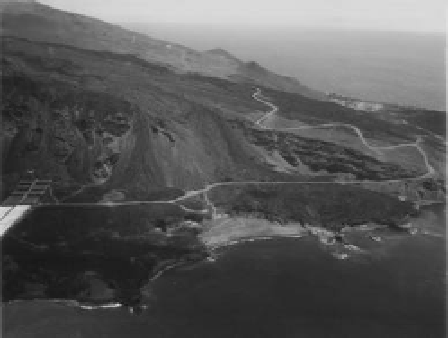
one. see Figure 5 where the san antonio Volcano
can be seen in the background and the Teneguía
Volcano at closer range. in the foreground part of
the old cliff can be observed that in the northern
direction became buried under the lava flows of
the san antonio and the Teneguía volcanoes.
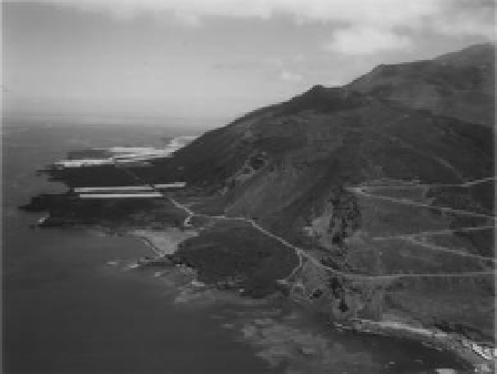
see Figure 6 where part of the old cliff can be
also observed with its packages of lava flows dip-
ping toward the sea with a small gradient, as well
as the upper part covered by the volcanic malpais,
and recent lava flows falling down the notches of
the former cliff that was turned down and buried.
Figure 5. aerial views of the southern zone where
Fuente santa spring could be found.
3
The PRoJecT oF The GalleRY
in the christmas season of 1995, the Mayor of
Fuencaliente de la Palma requested the
Direc-
ción General del Agua
of the
Consejería de Obras
Públicas del Gobierno de Canarias
(canary islands
Public Works Water Department) to carry out
all necessary investigations to try to find out the
Fuente santa spring.
We started studying all historical documents
where the morphology of the landscape was
described when the spring water still erupted. We
continued reading the attempts of those who pre-
ceded us and this is how, at the archives of the
municipalities, of the cultural societies, of the muse-
ums and even at the national archive of Madrid,
Figure 6.
Photograph, taken from the west.