Environmental Engineering Reference
In-Depth Information
eventually subside beneath sea level (lockwood &
lipman 1987). The island of hawaii, the largest
of the entire hawaiian chain, consists of five main
volcanoes: kilauea, Mauna loa, Mauna kea,
kohala and hualalai (
Fig. 1
). kilauea and Mauna
loa volcanoes are in the shield stage and erupt
frequently, hualalai and Mauna kea volcanoes
are in the post-shield stage and erupt every few
hundred to few thousand years, and kohala is dor-
mant, having passed through the post-shield stage.
kohala last erupted about 120 ka, Mauna kea
about 3.6 ka, and hualalai in 1800-1801 (Frey
et al. 1984).
hazard will need different seismic designs for the
structures to reach the same survival conditions. in
this sense, larger seismic hazard means increased
building costs. in order to assign a common meth-
odology to infer the probabilistic seismic hazard to
the different sites, the data from the Global seis-
mic hazard assessment Program (GshaP) were
analyzed (Giardini et al. 1999). GshaP hazard
maps depicts Peak-Ground-acceleration (PGa)
with 10% chance of exceedance in 50 years, as
illustrated in Fig. 2 and summarized in Table 1.
although all the sites are located within active
Table 1. seismic hazard expressed in terms of the Peak
Ground acceleration (PGa) with 10% chance of exceed-
ance for an exposure time of 50 years.
2.4
Central Andes, Chile
The andes is a mountain chain which extends along
the western edge of the south american plate. in
this region, the nazca Plate thrusts beneath south
america at a rate of approximately 64 and 79 mm/
year (angermann et al. 1999) in an east-north-east
direction, forming the Peru-chile trench in the
ocean's floor (
Fig. 1
). The nazca plate is divided
into several segments, whose main difference are
convergence direction and dipping angle of the
slab (Barazangi & isacks 1976). in general, normal
or steep dipping slab segments have angles around
30°, whereas in shallow segments this angle does
not exceed 15°. The angle of the segments also
define the presence of volcanic activity, since in
shallow segments there have not been volcanic
activity at least since the Miocene. Both Paranal
and cerro Ventarrones are located in the central
andes region (15°s to 27.5°s), above a steep dip-
ping segment of the nazca plate, hence volcanic
activity is present, although this takes place more
than 200 km eastwards of the sites. in this sense,
volcanic activity ceased in the area of the observa-
tories more than 20 million years ago. Unlike the
low viscosity-high temperature magmas of hawaii,
the high viscosity and low temperature of the mag-
mas in the central andes generate explosive erup-
tions that eject large eruptive columns.
observatory
PGa (g)
Mauna kea
0.5
Paranal
0.47
Ventarrones
0.42
Roque de los Muchachos
0.05
el Teide
0.06
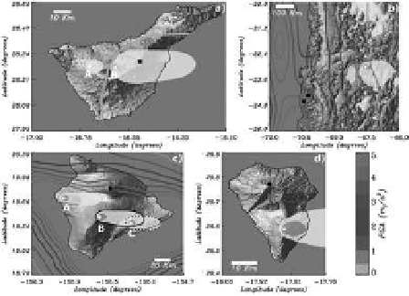
Figure 2. The contour lines represent the probabilis-
tic seismic hazard (peak ground acceleration with 10%
chance of being exceeded in 50 years), obtained from
the GshaP project. The spatial distribution of ashfall
(at least 1 cm) after the explosive eruptions of the vents
represented by filled white circles. The observatories are
marked as black filled squares.
Panel a
) The yellow semi-
transparent areas represent the extent of tephra fall after
a Vei = 2 eruption (a) and a Vei = 4 Montana Blanca
type eruption (B) in Tenerife, canary islands.
Panel b
)
The yellow and orange semi-transparent areas represent
the extent of tephra fall after a Vei = 4 and a Vei = 6
eruption of lascar volcano, in chile.
Panel c
) The yellow
and orange semi-transparent areas represent the extent
of tephra fall after a Vei = 2 and a Vei = 3 eruptions
of hualalai (a), Mauna loa (B) and kilauea (c) vol-
canoes, in hawaii.
Panel d
) The yellow and orange semi-
transparent areas represent the extent of tephra fall after
a Vei = 2 and a Vei = 3 eruptions of cumbre Vieja vol-
cano, in la Palma, canary islands.
3
seisMic haZaRD analYsis
seismic hazard is definied as the probabilistic
measure of ground shaking associated to the
recurrence of earthquakes. hazard assessment for
buildings and other structures commonly specifies
10% chance of exceedance of some ground motion
parameter for an exposure time of 50 years, cor-
responding to a return period of 475 years. The
operational and survival conditions of telescope
structures will depend on the ground shaking level
(seismic hazard) and the seismic design of the struc-
ture. Thus, two sites with different levels of seismic