Environmental Engineering Reference
In-Depth Information
Design and construction of the Machico-caniçal expressway
tunnels
c.J.o. Baião, J.M. Brito, a.R.J. Freitas, s.P.P. Rosa & M.F.M. conceição
Cenorgeo—Engenharia Geotécnica Lda., Lisboa, Portugal
aBsTRacT: The Machico-caniçal expressway, 8 km in length, is part of the Madeira island's new
development program, which connects Funchal city to caniçal village via a continuous expressway along
the island's southern coast. This expressway crosses an extremely mountainous region affected by the
existence of two very heterogeneous geological volcanic complexes, generally covered by unstable slope
deposits or by thick alluvial deposits, leading to the construction of a wide range of civil engineering
works. This paper presents the main aspects related with the design and construction of six double tunnels
along the referred expressway, as well as a number of safety aspects related to these tunnels.
1
inTRoDUcTion oVeRall
consiDeRaTions
make the best use of the rock-mass resistance and
the existing local conditions, hence avoiding early
on (or minimising the effects), and as far as pos-
sible, the more unfavourable zones, at times sub-
stantially conditioned by the existence of slope
and alluvial deposits, and seams associated with
the presence of water.
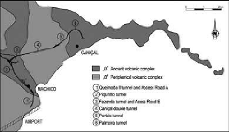
our focus will be Machico's region, where
the expressway closely follows the right bank of
Machico's stream mid-slope until turning east-
wards where it crosses this stream. on this initial
stretch, with an extension of 2050 m, are inserted
the Piquinho and Fazenda double tunnels, as well
and natal valleys on the caniçal side are reached
via the double tunnel of caniçal, a tunnel with
2100 m which crosses the mountain bedrock with
more than 300 m covering. on the final stretch
on the caniçal side, with approximately 2145 m,
The geotechnical works associated with the new
roadways of the Madeira island, in particular
the tunnels, are substantially affected by both the
extensive heterogeneity, the structural and litho-
logical complexity of the volcanic formations and
the rugged terrain. in addition to this, a dense
occupation of the land is often found along the
defined road profiles (Brito et al. 2005). The com-
bination of these factors led to the conception of
a varied range of structural solutions with specific
characteristics, at times with a degree of originality
in order to achieve economic solutions adapted to
the topographic and geological conditions, based
on the latest technologies and most evolved con-
struction processes.
Major technological development and knowl-
edge attained within the domain of engineering
have enabled the constricting results of nature's
modelling to be overcome. We would point out
the use of powerful means of earth removal with
impressive production rates, the sprayed concrete
and soil nailing applied as temporary tunnel lin-
ings, the laying of large amounts of concrete as
definitive tunnel linings using large-scale metallic
formworks and the use of the jet grouting tech-
nique at affordable costs, complemented with
an improved knowledge of volcanic formations
resulting from geotechnical investigation and an
accumulated experience. it is worth pointing out
the extreme importance of having, as soon as the
conception phase of the route itself, the most in-
depth knowledge possible of geomorphologic and
geological-geotechnical conditions, in order to
Figure 1.
Volcanic complexes of Machico-caniçal
expressway.