Environmental Engineering Reference
In-Depth Information
5
ResUlTs anD DiscUssion
as explained in the methodology, the results
obtained from the above tests were as follows.
in Tables 1 and 2 shown above, are collected
the data more representative of the existing land
in santa cruz de Tenerife. on these data we have
relied to establish the most suitable type of founda-
tion for the terrain and the type of construction.
The values listed are extremely variable, which is
characteristic of volcanic soils.
Despite having made a separation of ter-
rain according to their lithotypes they cannot be
considered individually. These soils and rocks are
embedded in the land and their response to the
solicitations is a mixture of both.
For this reason the municipality is divided into
several zones, which are distinguished by their
morphology, generated by eruptive processes that
have created this sector of the island. each mor-
phology is associated with a type of rock or soil
characteristic, shown in Table 3. This makes it
easier to classify which enshrine different types of
foundations.
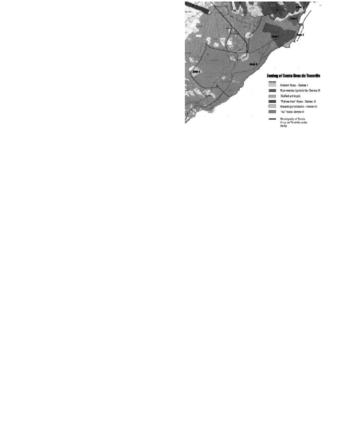
Figure 8 shows the zoning of the urban area
based on their morphology. Zone 1 covers anaga's
Residential, founded on ancient lava (series i)
and Zone 2 includes Toscal district, which as its
name suggests is situated tuff or on non-welded
ignimbrites.
anthropic fillers are groups as Zone 3 and, like
the Zone 5 (formed by basaltic pyroclastics), have a
singular behavior that hinders the construction of
large buildings. Most of the city of santa cruz is
set up on “aa” and “pahoehoe” lavas and there are
represented as Zone 4 and Zone 6.
“aa” flows are characterized by being exposed
to an alternation of lava and slag, which creates a
problem to choose the most appropriate type of
Figure 8.
Zoning of santa cruz de Tenerife.
foundation for each building. “Pahoehoe” lavas
have a peculiarity of having large and small cavi-
ties, which should be evaluated by the geotechnical
study to give them the appropriate treatment.
The basaltic Pyroclastics are located forming
independent units like Taco's Mountain. Buildings
in these areas are low-rise and require treatment
of the terrain. The same applies to the buildings
on landfills in the area of Puerto de Tenerife, in
Zone 3 (alcibiades serrano, 1996).
as there are many constraints on each of the
sectors, has prepared a chart that summarizes and
6
conclUsions
The terrain that forms the canary islands is very
diverse, and presents very particular problems. The
rocks forming the basement have suitable proper-
ties for construction of foundations because their
resistance values are high; nevertheless, the prob-
lem is that it no appear alone in the environment.
The rocks outcrop surrounded by other less
resistant materials (slag), and after several cycles of
erosion, are also involved in volcanic soils of dif-
ferent origin. This plurality generates a decline in
property values and requires an analysis to quan-
tify the consequences.
The study seeks to encompass the solutions over
time, based on the investigation and experimenta-
tion developed until now.
This aims to carry out a guide to facilitate and
expedite future constructions and it can be extrap-
olated to other parts of the world with similar ter-
rain to those found in this province.
Table 3.
correspondence between areas and terrains.
soils
Rocks
Zone 1
sleBss
RlBoPM
Zone 2
saRTUFF
RWPRiGn
RlBoPM
Zone 3
-
(1)
-
(1)
Zone 4
sleBss
RlBoPV
RlBaFV
RlBes
Zone 5
siPRlPs
RlTRQB
Zone 6
sleBss
RlBoPM
saRBas
RlBaFM
sliM
RleBss
siPRPRs
RlBes
saRTUFF
*
(1)
stuffed anthropic.